地址: 19600 (From 19600 To 19699) COUNTY ROAD 1535, ADA, OK 74820-0007, USA
74820-0007是什么? 74820-0007是 19600 (From 19600 To 19699) COUNTY ROAD 1535, ADA, OK, USA的5加4位邮编。下面是详细信息。
74820-0007基本信息

-
邮政编码5加4:
74820-0007 -
邮政编码5:
74820 -
加4?00074-digits that are used to identify a geographic segment within the 5-digit delivery area, such as a city block or a group of apartments or an individual high-volume receiver of mail, or any other unit that could use an extra identifier to aid in efficient mail sorting and delivery. This code is the low end of the range of +4 Codes that pertain to this ZIP Code. ZIP+4 Codes associated with nondelivery areas are composed of valid ZIP sector numbers and "ND" for the ZIP segment number, for example 12345-12ND. Non-deliverable areas are areas to which the USPS does not deliver mail, such as vacant lots and land that borders railroad tracks. Mailers should not match an address identified as a nondelivery area. If you absolutely must have numeric characters in the Plus4Code column, you may treat "ND" values as "00" (zero zero).:
-
国家:
U.S. - 美国 -
州:
OK - 俄克拉何马州 -
区县:
CountyFIPS: 40123 - Pontotoc County -
城市:
ADA -
街道?COUNTY ROAD 1535The official name of a street as assigned by a local governing authority. The Street Name column contains only the street name and does not include directionals (EAST, WEST, etc.) or suffixes (ST, DR, BLVD, etc.). This element may also contain literals, such as PO BOX, GENERAL DELIVERY, USS, PSC, or UNIT. Numeric street names that have numeric components that are four characters (or less) in length at are justified such that the low-order digit of the number is positioned in the fourth position of the street name column. This shift is made so that the numeric street names appear in numeric sequence.:
-
记录类型?S: 街道An alphabetic value that identifies the type of data in the record. Record type codes include the following: G = General delivery H = Highrise F = Firm S = Street P = PO box R = Rural route/highway contract:
地址

- 主要地址低位数字?
A house, rural route, highway contract box, or post office box number; the numeric or alphanumeric component of an address preceding the street name; the low-end address in a range of addresses. Often referred to as house number.: 19600
- 主要地址高位数字?
A house, rural route, contract box, or Post Office box number. The numeric or alphanumeric component of an address preceding the street name. The high-end address in a range of addresses. Often referred to as house number.: 19699
- 主要地址奇/偶码?
Code that identifies the side or sides of a street for which a given address range is applicable. For street, highrise, firm and multi-carrier records, B = Both sides of a street, E = Even side of a street (even-numbered addresses in the range); O = Odd side of a street (odd-numbered addresses in the range). For general delivery, post office box, and rural route/highway contract records, this code will always be "B" (both).: Both of Odd and Even
- 主要范围: 19600, 19601, 19602, 19603, 19604, 19605, 19606, 19607, 19608, 19609, 19610, 19611, 19612, 19613, 19614, 19615, 19616, 19617, 19618, 19619, 19620, 19621, 19622, 19623, 19624, 19625, 19626, 19627, 19628, 19629, 19630, 19631, 19632, 19633, 19634, 19635, 19636, 19637, 19638, 19639, 19640, 19641, 19642, 19643, 19644, 19645, 19646, 19647, 19648, 19649, 19650, 19651, 19652, 19653, 19654, 19655, 19656, 19657, 19658, 19659, 19660, 19661, 19662, 19663, 19664, 19665, 19666, 19667, 19668, 19669, 19670, 19671, 19672, 19673, 19674, 19675, 19676, 19677, 19678, 19679, 19680, 19681, 19682, 19683, 19684, 19685, 19686, 19687, 19688, 19689, 19690, 19691, 19692, 19693, 19694, 19695, 19696, 19697, 19698, 19699.
请单击"更多地址示例"查看整个列表。
19600 COUNTY ROAD 1535, ADA, OK 74820-0007
19601 COUNTY ROAD 1535, ADA, OK 74820-0007
19602 COUNTY ROAD 1535, ADA, OK 74820-0007
19603 COUNTY ROAD 1535, ADA, OK 74820-0007
19604 COUNTY ROAD 1535, ADA, OK 74820-0007
19605 COUNTY ROAD 1535, ADA, OK 74820-0007
19606 COUNTY ROAD 1535, ADA, OK 74820-0007
19607 COUNTY ROAD 1535, ADA, OK 74820-0007
19608 COUNTY ROAD 1535, ADA, OK 74820-0007
19609 COUNTY ROAD 1535, ADA, OK 74820-0007
19610 COUNTY ROAD 1535, ADA, OK 74820-0007
19611 COUNTY ROAD 1535, ADA, OK 74820-0007
19612 COUNTY ROAD 1535, ADA, OK 74820-0007
19613 COUNTY ROAD 1535, ADA, OK 74820-0007
19614 COUNTY ROAD 1535, ADA, OK 74820-0007
19615 COUNTY ROAD 1535, ADA, OK 74820-0007
19616 COUNTY ROAD 1535, ADA, OK 74820-0007
19617 COUNTY ROAD 1535, ADA, OK 74820-0007
19618 COUNTY ROAD 1535, ADA, OK 74820-0007
19619 COUNTY ROAD 1535, ADA, OK 74820-0007
19620 COUNTY ROAD 1535, ADA, OK 74820-0007
19621 COUNTY ROAD 1535, ADA, OK 74820-0007
19622 COUNTY ROAD 1535, ADA, OK 74820-0007
19623 COUNTY ROAD 1535, ADA, OK 74820-0007
19624 COUNTY ROAD 1535, ADA, OK 74820-0007
19625 COUNTY ROAD 1535, ADA, OK 74820-0007
19626 COUNTY ROAD 1535, ADA, OK 74820-0007
19627 COUNTY ROAD 1535, ADA, OK 74820-0007
19628 COUNTY ROAD 1535, ADA, OK 74820-0007
19629 COUNTY ROAD 1535, ADA, OK 74820-0007
19630 COUNTY ROAD 1535, ADA, OK 74820-0007
19631 COUNTY ROAD 1535, ADA, OK 74820-0007
19632 COUNTY ROAD 1535, ADA, OK 74820-0007
19633 COUNTY ROAD 1535, ADA, OK 74820-0007
19634 COUNTY ROAD 1535, ADA, OK 74820-0007
19635 COUNTY ROAD 1535, ADA, OK 74820-0007
19636 COUNTY ROAD 1535, ADA, OK 74820-0007
19637 COUNTY ROAD 1535, ADA, OK 74820-0007
19638 COUNTY ROAD 1535, ADA, OK 74820-0007
19639 COUNTY ROAD 1535, ADA, OK 74820-0007
19640 COUNTY ROAD 1535, ADA, OK 74820-0007
19641 COUNTY ROAD 1535, ADA, OK 74820-0007
19642 COUNTY ROAD 1535, ADA, OK 74820-0007
19643 COUNTY ROAD 1535, ADA, OK 74820-0007
19644 COUNTY ROAD 1535, ADA, OK 74820-0007
19645 COUNTY ROAD 1535, ADA, OK 74820-0007
19646 COUNTY ROAD 1535, ADA, OK 74820-0007
19647 COUNTY ROAD 1535, ADA, OK 74820-0007
19648 COUNTY ROAD 1535, ADA, OK 74820-0007
19649 COUNTY ROAD 1535, ADA, OK 74820-0007
19650 COUNTY ROAD 1535, ADA, OK 74820-0007
19651 COUNTY ROAD 1535, ADA, OK 74820-0007
19652 COUNTY ROAD 1535, ADA, OK 74820-0007
19653 COUNTY ROAD 1535, ADA, OK 74820-0007
19654 COUNTY ROAD 1535, ADA, OK 74820-0007
19655 COUNTY ROAD 1535, ADA, OK 74820-0007
19656 COUNTY ROAD 1535, ADA, OK 74820-0007
19657 COUNTY ROAD 1535, ADA, OK 74820-0007
19658 COUNTY ROAD 1535, ADA, OK 74820-0007
19659 COUNTY ROAD 1535, ADA, OK 74820-0007
19660 COUNTY ROAD 1535, ADA, OK 74820-0007
19661 COUNTY ROAD 1535, ADA, OK 74820-0007
19662 COUNTY ROAD 1535, ADA, OK 74820-0007
19663 COUNTY ROAD 1535, ADA, OK 74820-0007
19664 COUNTY ROAD 1535, ADA, OK 74820-0007
19665 COUNTY ROAD 1535, ADA, OK 74820-0007
19666 COUNTY ROAD 1535, ADA, OK 74820-0007
19667 COUNTY ROAD 1535, ADA, OK 74820-0007
19668 COUNTY ROAD 1535, ADA, OK 74820-0007
19669 COUNTY ROAD 1535, ADA, OK 74820-0007
19670 COUNTY ROAD 1535, ADA, OK 74820-0007
19671 COUNTY ROAD 1535, ADA, OK 74820-0007
19672 COUNTY ROAD 1535, ADA, OK 74820-0007
19673 COUNTY ROAD 1535, ADA, OK 74820-0007
19674 COUNTY ROAD 1535, ADA, OK 74820-0007
19675 COUNTY ROAD 1535, ADA, OK 74820-0007
19676 COUNTY ROAD 1535, ADA, OK 74820-0007
19677 COUNTY ROAD 1535, ADA, OK 74820-0007
19678 COUNTY ROAD 1535, ADA, OK 74820-0007
19679 COUNTY ROAD 1535, ADA, OK 74820-0007
19680 COUNTY ROAD 1535, ADA, OK 74820-0007
19681 COUNTY ROAD 1535, ADA, OK 74820-0007
19682 COUNTY ROAD 1535, ADA, OK 74820-0007
19683 COUNTY ROAD 1535, ADA, OK 74820-0007
19684 COUNTY ROAD 1535, ADA, OK 74820-0007
19685 COUNTY ROAD 1535, ADA, OK 74820-0007
19686 COUNTY ROAD 1535, ADA, OK 74820-0007
19687 COUNTY ROAD 1535, ADA, OK 74820-0007
19688 COUNTY ROAD 1535, ADA, OK 74820-0007
19689 COUNTY ROAD 1535, ADA, OK 74820-0007
19690 COUNTY ROAD 1535, ADA, OK 74820-0007
19691 COUNTY ROAD 1535, ADA, OK 74820-0007
19692 COUNTY ROAD 1535, ADA, OK 74820-0007
19693 COUNTY ROAD 1535, ADA, OK 74820-0007
19694 COUNTY ROAD 1535, ADA, OK 74820-0007
19695 COUNTY ROAD 1535, ADA, OK 74820-0007
19696 COUNTY ROAD 1535, ADA, OK 74820-0007
19697 COUNTY ROAD 1535, ADA, OK 74820-0007
19698 COUNTY ROAD 1535, ADA, OK 74820-0007
19699 COUNTY ROAD 1535, ADA, OK 74820-0007
地址示例
ADA OK 74820-0007
UNITED STATES OF AMERICA
74820-0007信封例子

-
这是美国信封例子。在左上角填写发件人信息,右下角填写收件人信息。必须要填写的信息有发件人和收件人的姓名、街道地址、城市、州还有邮政编码。收件人的地址示例仅供参考。通常来说,如果你不确定九位邮件,你可以仅仅填写五位邮编,以避免邮件丢失。

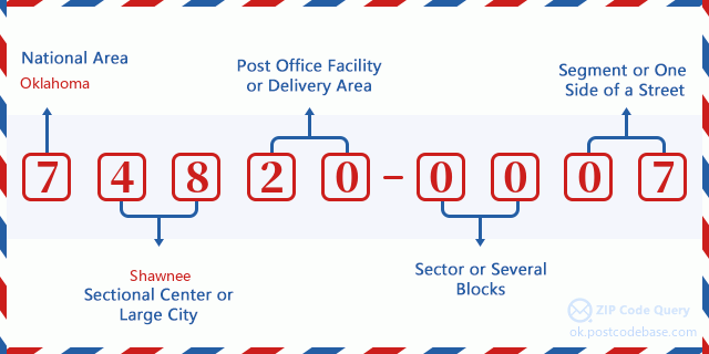
74820-0007基本含义
-
邮政编码 74820-0007 的每个数字代表什么?ZIP+4 Code由两部分组成,前五位数字可以定位到邮局,后四位数字可以确定五位数字递送区域内的一个地理区段。6-7位数字指定区域或几个街区,8-9位数字指定区段或街道的一侧。

- ·运输路线ID?
A 4-digit code assigned to a mail delivery or collection route within a 5-digit ZIP Code. The first character of this identification is alphabetical, and the last three are numeric: Bnnn = PO box Hnnn = Highway contract Rnnn = Rural route Cnnn = City delivery Gnnn = General delivery: R007 (农村线路)
- ·邮递附加低部?
The ZIP Add-On Low Sector and the ZIP Add-On Low Segment together form the ZIP Add-On Low Number. The ZIP Add-On Low Number is the last four positions of a ZIP+4 code; the low-end ZIP add-on in a range of codes; the add-on of the first ZIP+4 code in a consecutive series of ZIP+4 codes assigned to the delivery address. For example, most delivery addresses are assigned a single ZIP+4 code. However, large companies may be given a range of ZIP+4 codes that can be used to route mail to specific departments. A range of ZIP+4 codes can also be assigned to a corresponding range of post office boxes, and each box is mapped, one-to-one, with a ZIP+4 code in the range. A single post office box can also be assigned a range of ZIP+4 codes.: 00
- ·邮递附加低段?
The ZIP Add-On Low Sector and the ZIP Add-On Low Segment together form the ZIP Add-On Low Number. The ZIP Add-On Low Number is the last four positions of a ZIP+4 code; the low-end ZIP add-on in a range of codes; the add-on of the first ZIP+4 code in a consecutive series of ZIP+4 codes assigned to the delivery address. For example, most delivery addresses are assigned a single ZIP+4 code. However, large companies may be given a range of ZIP+4 codes that can be used to route mail to specific departments. A range of ZIP+4 codes can also be assigned to a corresponding range of post office boxes, and each box is mapped, one-to-one, with a ZIP+4 code in the range. A single post office box can also be assigned a range of ZIP+4 codes.: 07
- ·邮递附加高部?
The ZIP Add-On High Sector and the ZIP Add-On High Segment together form the ZIP Add-On High Number, which is the high-end ZIP add-on in a range of codes; the add-on of the last ZIP+4 code in a consecutive series of ZIP+4 codes assigned to the delivery address. Most delivery addresses are assigned a single ZIP+4 code; however, large companies may be given a range of ZIP+4 codes that can be used to route mail to specific departments. A range of ZIP+4 codes can also be assigned to a corresponding range of post office boxes, and each box is mapped, one-to-one, with a ZIP+4 code in the range. A single post office box can also be assigned a range of ZIP+4 codes. (See also ZIP Add-On Code.): 00
- ·邮递附加高段?
The ZIP Add-On High Sector and the ZIP Add-On High Segment together form the ZIP Add-On High Number, which is the high-end ZIP add-on in a range of codes; the add-on of the last ZIP+4 code in a consecutive series of ZIP+4 codes assigned to the delivery address. Most delivery addresses are assigned a single ZIP+4 code; however, large companies may be given a range of ZIP+4 codes that can be used to route mail to specific departments. A range of ZIP+4 codes can also be assigned to a corresponding range of post office boxes, and each box is mapped, one-to-one, with a ZIP+4 code in the range. A single post office box can also be assigned a range of ZIP+4 codes. (See also ZIP Add-On Code.): 07
- ·邮编附加: 0007
- ·范围?
The range of +4 codes. Summing the +4 Code and the +4 Range will give you the high end of the range of +4 Codes that pertain to this ZIP Code.: 0
- ·基本替代代码?
Code that specifies whether a record is a base (preferred) or alternate record. Base records (represented as "B") can represent a range of addresses or an individual address, such as a firm record, while alternate records (represented as "A") are individual delivery points. Government deliveries will only be listed on alternate records with the appropriate government building indicator (federal, state, or city) set.: 基本
- ·财务数字?
A code assigned to Postal Service facilities (primarily post offices) to collect cost and statistical data and compile revenue and expense data. The state number comprises the first two positions of the finance number.: 390033
- ·国会分区数字?
A standard value identifying a geographic area within the United States served by a member of the US House of Representatives or Senate. If Army/Air Force (APO) or fleet post office (FPO), this column will be blank. If there is only one member of Congress within a state, the code will be "AL" (at large).: 04
- ·最后行城市州代码?
An index to the City State file that provides the preferred last-line name for this address range.: W21815
在线地图

这是地址19600 COUNTY ROAD 1535 ADA匹配的在线电子地图。您可以使用图中按钮来移动、缩放。该地图信息仅供参考。
地址: 19600 (From 19600 To 19699) COUNTY ROAD 1535, ADA, OK 74820-0007, USA
评论


添加新评论