Adres: 2400 (From 2400 To 2499) COUNTY ROAD 1203, BLANCHARD, OK 73010-2802, USA
73010-2802 nedir? 73010-2802 , 2400 (From 2400 To 2499) COUNTY ROAD 1203, BLANCHARD, OK, USA'in bir 5 Artı 4 ZIP KODU numarasıdır. Aşağıda detaylı bilgi yer almaktadır.
73010-2802 Temel Bilgiler

-
Posta Kodu 5 Plus 4:
73010-2802 -
Posta Kodu 5:
73010 -
Plus 4?28024-digits that are used to identify a geographic segment within the 5-digit delivery area, such as a city block or a group of apartments or an individual high-volume receiver of mail, or any other unit that could use an extra identifier to aid in efficient mail sorting and delivery. This code is the low end of the range of +4 Codes that pertain to this ZIP Code. ZIP+4 Codes associated with nondelivery areas are composed of valid ZIP sector numbers and "ND" for the ZIP segment number, for example 12345-12ND. Non-deliverable areas are areas to which the USPS does not deliver mail, such as vacant lots and land that borders railroad tracks. Mailers should not match an address identified as a nondelivery area. If you absolutely must have numeric characters in the Plus4Code column, you may treat "ND" values as "00" (zero zero).:
-
Ülke:
U.S. - Amerika Birleşik Devletleri -
Eyalet:
OK - Oklahoma -
İlçe:
CountyFIPS: 40051 - Grady County -
Şehir:
BLANCHARD -
Sokak?COUNTY ROAD 1203The official name of a street as assigned by a local governing authority. The Street Name column contains only the street name and does not include directionals (EAST, WEST, etc.) or suffixes (ST, DR, BLVD, etc.). This element may also contain literals, such as PO BOX, GENERAL DELIVERY, USS, PSC, or UNIT. Numeric street names that have numeric components that are four characters (or less) in length at are justified such that the low-order digit of the number is positioned in the fourth position of the street name column. This shift is made so that the numeric street names appear in numeric sequence.:
-
Kayıt Türü?S: SokakAn alphabetic value that identifies the type of data in the record. Record type codes include the following: G = General delivery H = Highrise F = Firm S = Street P = PO box R = Rural route/highway contract:
Adres

- Adres Birincil Düşük Numarası?
A house, rural route, highway contract box, or post office box number; the numeric or alphanumeric component of an address preceding the street name; the low-end address in a range of addresses. Often referred to as house number.: 2400
- Adres Birincil Yüksek Numarası?
A house, rural route, contract box, or Post Office box number. The numeric or alphanumeric component of an address preceding the street name. The high-end address in a range of addresses. Often referred to as house number.: 2499
- Adres Birincil Tek / Çift Kodu?
Code that identifies the side or sides of a street for which a given address range is applicable. For street, highrise, firm and multi-carrier records, B = Both sides of a street, E = Even side of a street (even-numbered addresses in the range); O = Odd side of a street (odd-numbered addresses in the range). For general delivery, post office box, and rural route/highway contract records, this code will always be "B" (both).: Both of Odd and Even
- Birincil Dizi: 2400, 2401, 2402, 2403, 2404, 2405, 2406, 2407, 2408, 2409, 2410, 2411, 2412, 2413, 2414, 2415, 2416, 2417, 2418, 2419, 2420, 2421, 2422, 2423, 2424, 2425, 2426, 2427, 2428, 2429, 2430, 2431, 2432, 2433, 2434, 2435, 2436, 2437, 2438, 2439, 2440, 2441, 2442, 2443, 2444, 2445, 2446, 2447, 2448, 2449, 2450, 2451, 2452, 2453, 2454, 2455, 2456, 2457, 2458, 2459, 2460, 2461, 2462, 2463, 2464, 2465, 2466, 2467, 2468, 2469, 2470, 2471, 2472, 2473, 2474, 2475, 2476, 2477, 2478, 2479, 2480, 2481, 2482, 2483, 2484, 2485, 2486, 2487, 2488, 2489, 2490, 2491, 2492, 2493, 2494, 2495, 2496, 2497, 2498, 2499.
Tüm listeyi görmek için lütfen "Daha Fazla Adres Örneği"'e tıklayın
2400 COUNTY ROAD 1203, BLANCHARD, OK 73010-2802
2401 COUNTY ROAD 1203, BLANCHARD, OK 73010-2802
2402 COUNTY ROAD 1203, BLANCHARD, OK 73010-2802
2403 COUNTY ROAD 1203, BLANCHARD, OK 73010-2802
2404 COUNTY ROAD 1203, BLANCHARD, OK 73010-2802
2405 COUNTY ROAD 1203, BLANCHARD, OK 73010-2802
2406 COUNTY ROAD 1203, BLANCHARD, OK 73010-2802
2407 COUNTY ROAD 1203, BLANCHARD, OK 73010-2802
2408 COUNTY ROAD 1203, BLANCHARD, OK 73010-2802
2409 COUNTY ROAD 1203, BLANCHARD, OK 73010-2802
2410 COUNTY ROAD 1203, BLANCHARD, OK 73010-2802
2411 COUNTY ROAD 1203, BLANCHARD, OK 73010-2802
2412 COUNTY ROAD 1203, BLANCHARD, OK 73010-2802
2413 COUNTY ROAD 1203, BLANCHARD, OK 73010-2802
2414 COUNTY ROAD 1203, BLANCHARD, OK 73010-2802
2415 COUNTY ROAD 1203, BLANCHARD, OK 73010-2802
2416 COUNTY ROAD 1203, BLANCHARD, OK 73010-2802
2417 COUNTY ROAD 1203, BLANCHARD, OK 73010-2802
2418 COUNTY ROAD 1203, BLANCHARD, OK 73010-2802
2419 COUNTY ROAD 1203, BLANCHARD, OK 73010-2802
2420 COUNTY ROAD 1203, BLANCHARD, OK 73010-2802
2421 COUNTY ROAD 1203, BLANCHARD, OK 73010-2802
2422 COUNTY ROAD 1203, BLANCHARD, OK 73010-2802
2423 COUNTY ROAD 1203, BLANCHARD, OK 73010-2802
2424 COUNTY ROAD 1203, BLANCHARD, OK 73010-2802
2425 COUNTY ROAD 1203, BLANCHARD, OK 73010-2802
2426 COUNTY ROAD 1203, BLANCHARD, OK 73010-2802
2427 COUNTY ROAD 1203, BLANCHARD, OK 73010-2802
2428 COUNTY ROAD 1203, BLANCHARD, OK 73010-2802
2429 COUNTY ROAD 1203, BLANCHARD, OK 73010-2802
2430 COUNTY ROAD 1203, BLANCHARD, OK 73010-2802
2431 COUNTY ROAD 1203, BLANCHARD, OK 73010-2802
2432 COUNTY ROAD 1203, BLANCHARD, OK 73010-2802
2433 COUNTY ROAD 1203, BLANCHARD, OK 73010-2802
2434 COUNTY ROAD 1203, BLANCHARD, OK 73010-2802
2435 COUNTY ROAD 1203, BLANCHARD, OK 73010-2802
2436 COUNTY ROAD 1203, BLANCHARD, OK 73010-2802
2437 COUNTY ROAD 1203, BLANCHARD, OK 73010-2802
2438 COUNTY ROAD 1203, BLANCHARD, OK 73010-2802
2439 COUNTY ROAD 1203, BLANCHARD, OK 73010-2802
2440 COUNTY ROAD 1203, BLANCHARD, OK 73010-2802
2441 COUNTY ROAD 1203, BLANCHARD, OK 73010-2802
2442 COUNTY ROAD 1203, BLANCHARD, OK 73010-2802
2443 COUNTY ROAD 1203, BLANCHARD, OK 73010-2802
2444 COUNTY ROAD 1203, BLANCHARD, OK 73010-2802
2445 COUNTY ROAD 1203, BLANCHARD, OK 73010-2802
2446 COUNTY ROAD 1203, BLANCHARD, OK 73010-2802
2447 COUNTY ROAD 1203, BLANCHARD, OK 73010-2802
2448 COUNTY ROAD 1203, BLANCHARD, OK 73010-2802
2449 COUNTY ROAD 1203, BLANCHARD, OK 73010-2802
2450 COUNTY ROAD 1203, BLANCHARD, OK 73010-2802
2451 COUNTY ROAD 1203, BLANCHARD, OK 73010-2802
2452 COUNTY ROAD 1203, BLANCHARD, OK 73010-2802
2453 COUNTY ROAD 1203, BLANCHARD, OK 73010-2802
2454 COUNTY ROAD 1203, BLANCHARD, OK 73010-2802
2455 COUNTY ROAD 1203, BLANCHARD, OK 73010-2802
2456 COUNTY ROAD 1203, BLANCHARD, OK 73010-2802
2457 COUNTY ROAD 1203, BLANCHARD, OK 73010-2802
2458 COUNTY ROAD 1203, BLANCHARD, OK 73010-2802
2459 COUNTY ROAD 1203, BLANCHARD, OK 73010-2802
2460 COUNTY ROAD 1203, BLANCHARD, OK 73010-2802
2461 COUNTY ROAD 1203, BLANCHARD, OK 73010-2802
2462 COUNTY ROAD 1203, BLANCHARD, OK 73010-2802
2463 COUNTY ROAD 1203, BLANCHARD, OK 73010-2802
2464 COUNTY ROAD 1203, BLANCHARD, OK 73010-2802
2465 COUNTY ROAD 1203, BLANCHARD, OK 73010-2802
2466 COUNTY ROAD 1203, BLANCHARD, OK 73010-2802
2467 COUNTY ROAD 1203, BLANCHARD, OK 73010-2802
2468 COUNTY ROAD 1203, BLANCHARD, OK 73010-2802
2469 COUNTY ROAD 1203, BLANCHARD, OK 73010-2802
2470 COUNTY ROAD 1203, BLANCHARD, OK 73010-2802
2471 COUNTY ROAD 1203, BLANCHARD, OK 73010-2802
2472 COUNTY ROAD 1203, BLANCHARD, OK 73010-2802
2473 COUNTY ROAD 1203, BLANCHARD, OK 73010-2802
2474 COUNTY ROAD 1203, BLANCHARD, OK 73010-2802
2475 COUNTY ROAD 1203, BLANCHARD, OK 73010-2802
2476 COUNTY ROAD 1203, BLANCHARD, OK 73010-2802
2477 COUNTY ROAD 1203, BLANCHARD, OK 73010-2802
2478 COUNTY ROAD 1203, BLANCHARD, OK 73010-2802
2479 COUNTY ROAD 1203, BLANCHARD, OK 73010-2802
2480 COUNTY ROAD 1203, BLANCHARD, OK 73010-2802
2481 COUNTY ROAD 1203, BLANCHARD, OK 73010-2802
2482 COUNTY ROAD 1203, BLANCHARD, OK 73010-2802
2483 COUNTY ROAD 1203, BLANCHARD, OK 73010-2802
2484 COUNTY ROAD 1203, BLANCHARD, OK 73010-2802
2485 COUNTY ROAD 1203, BLANCHARD, OK 73010-2802
2486 COUNTY ROAD 1203, BLANCHARD, OK 73010-2802
2487 COUNTY ROAD 1203, BLANCHARD, OK 73010-2802
2488 COUNTY ROAD 1203, BLANCHARD, OK 73010-2802
2489 COUNTY ROAD 1203, BLANCHARD, OK 73010-2802
2490 COUNTY ROAD 1203, BLANCHARD, OK 73010-2802
2491 COUNTY ROAD 1203, BLANCHARD, OK 73010-2802
2492 COUNTY ROAD 1203, BLANCHARD, OK 73010-2802
2493 COUNTY ROAD 1203, BLANCHARD, OK 73010-2802
2494 COUNTY ROAD 1203, BLANCHARD, OK 73010-2802
2495 COUNTY ROAD 1203, BLANCHARD, OK 73010-2802
2496 COUNTY ROAD 1203, BLANCHARD, OK 73010-2802
2497 COUNTY ROAD 1203, BLANCHARD, OK 73010-2802
2498 COUNTY ROAD 1203, BLANCHARD, OK 73010-2802
2499 COUNTY ROAD 1203, BLANCHARD, OK 73010-2802
Adres Örnek
BLANCHARD OK 73010-2802
UNITED STATES OF AMERICA
73010-2802 Zarf Örneği

-
Bu, ABD zarfına bir örnektir. Gönderenin bilgilerini sol üstte ve alıcı bilgilerini sağ altta doldurun. Gerekli bilgiler gönderenin/alıcının tam adı, açık adresi, şehri, eyaleti ve posta kodudur. Alıcı adres bilgileri referansınız için verilmiştir. Genel olarak, 9 basamaklı posta kodunun tam olduğundan emin değilseniz, paketin kaybolmasını önlemek için yalnızca 5 basamaklı posta kodunu girebilirsiniz.

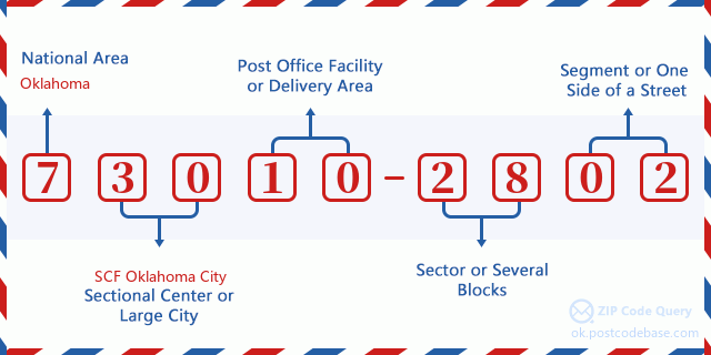
73010-2802 Temel Anlam
-
Posta Kodu 73010-2802'in her basamağı ne anlama geliyor? Posta+4 Kodu iki bölümden oluşur, ilk beş basamak postanede bulunabilir ve son dört basamak beş basamaklı teslimat alanı içindeki bir coğrafi segmenti tanımlayabilir. 6-7 basamak, sektörü veya birkaç bloğu belirtir ve 8-9 basamak, bir sokağın segmentini veya bir tarafını belirtir.

- ·Taşıyıcı Rota ID?
A 4-digit code assigned to a mail delivery or collection route within a 5-digit ZIP Code. The first character of this identification is alphabetical, and the last three are numeric: Bnnn = PO box Hnnn = Highway contract Rnnn = Rural route Cnnn = City delivery Gnnn = General delivery: R004 (Kırsal rota)
- ·ZIP Eklenti Düşük Sektör?
The ZIP Add-On Low Sector and the ZIP Add-On Low Segment together form the ZIP Add-On Low Number. The ZIP Add-On Low Number is the last four positions of a ZIP+4 code; the low-end ZIP add-on in a range of codes; the add-on of the first ZIP+4 code in a consecutive series of ZIP+4 codes assigned to the delivery address. For example, most delivery addresses are assigned a single ZIP+4 code. However, large companies may be given a range of ZIP+4 codes that can be used to route mail to specific departments. A range of ZIP+4 codes can also be assigned to a corresponding range of post office boxes, and each box is mapped, one-to-one, with a ZIP+4 code in the range. A single post office box can also be assigned a range of ZIP+4 codes.: 28
- ·ZIP Eklenti Düşük Segment?
The ZIP Add-On Low Sector and the ZIP Add-On Low Segment together form the ZIP Add-On Low Number. The ZIP Add-On Low Number is the last four positions of a ZIP+4 code; the low-end ZIP add-on in a range of codes; the add-on of the first ZIP+4 code in a consecutive series of ZIP+4 codes assigned to the delivery address. For example, most delivery addresses are assigned a single ZIP+4 code. However, large companies may be given a range of ZIP+4 codes that can be used to route mail to specific departments. A range of ZIP+4 codes can also be assigned to a corresponding range of post office boxes, and each box is mapped, one-to-one, with a ZIP+4 code in the range. A single post office box can also be assigned a range of ZIP+4 codes.: 02
- ·ZIP Eklenti Yüksek Sektör?
The ZIP Add-On High Sector and the ZIP Add-On High Segment together form the ZIP Add-On High Number, which is the high-end ZIP add-on in a range of codes; the add-on of the last ZIP+4 code in a consecutive series of ZIP+4 codes assigned to the delivery address. Most delivery addresses are assigned a single ZIP+4 code; however, large companies may be given a range of ZIP+4 codes that can be used to route mail to specific departments. A range of ZIP+4 codes can also be assigned to a corresponding range of post office boxes, and each box is mapped, one-to-one, with a ZIP+4 code in the range. A single post office box can also be assigned a range of ZIP+4 codes. (See also ZIP Add-On Code.): 28
- ·ZIP Eklenti Yüksek Segment?
The ZIP Add-On High Sector and the ZIP Add-On High Segment together form the ZIP Add-On High Number, which is the high-end ZIP add-on in a range of codes; the add-on of the last ZIP+4 code in a consecutive series of ZIP+4 codes assigned to the delivery address. Most delivery addresses are assigned a single ZIP+4 code; however, large companies may be given a range of ZIP+4 codes that can be used to route mail to specific departments. A range of ZIP+4 codes can also be assigned to a corresponding range of post office boxes, and each box is mapped, one-to-one, with a ZIP+4 code in the range. A single post office box can also be assigned a range of ZIP+4 codes. (See also ZIP Add-On Code.): 02
- ·Posta Kodu Eklenti: 2802
- ·Dizi?
The range of +4 codes. Summing the +4 Code and the +4 Range will give you the high end of the range of +4 Codes that pertain to this ZIP Code.: 0
- ·Taban Alternatif Kod?
Code that specifies whether a record is a base (preferred) or alternate record. Base records (represented as "B") can represent a range of addresses or an individual address, such as a firm record, while alternate records (represented as "A") are individual delivery points. Government deliveries will only be listed on alternate records with the appropriate government building indicator (federal, state, or city) set.: Temel
- ·Finans Numarası?
A code assigned to Postal Service facilities (primarily post offices) to collect cost and statistical data and compile revenue and expense data. The state number comprises the first two positions of the finance number.: 390825
- ·Kongre Bölge Numarası?
A standard value identifying a geographic area within the United States served by a member of the US House of Representatives or Senate. If Army/Air Force (APO) or fleet post office (FPO), this column will be blank. If there is only one member of Congress within a state, the code will be "AL" (at large).: 04
- ·Tercih Edilen Son Hat Şehir Durum Anahtarı?
An index to the City State file that provides the preferred last-line name for this address range.: W21875
Çevrimiçi Harita

Bu 2400 COUNTY ROAD 1203 BLANCHARD adresinin çevrimiçi haritasıdır. Hareket ettirmek ve yakınlaştırmak / uzaklaştırmak için düğmeyi kullanabilirsiniz. Harita bilgisi sadece referans içindir.
Adres: 2400 (From 2400 To 2499) COUNTY ROAD 1203, BLANCHARD, OK 73010-2802, USA
Yorum


Yeni yorum ekle