Adres: 18100 (From 18100 To 18199) COUNTY ROAD 1330, ANADARKO, OK 73005-2000, USA
73005-2000 nedir? 73005-2000 , 18100 (From 18100 To 18199) COUNTY ROAD 1330, ANADARKO, OK, USA'in bir 5 Artı 4 ZIP KODU numarasıdır. Aşağıda detaylı bilgi yer almaktadır.
73005-2000 Temel Bilgiler

-
Posta Kodu 5 Plus 4:
73005-2000 -
Posta Kodu 5:
73005 -
Plus 4?20004-digits that are used to identify a geographic segment within the 5-digit delivery area, such as a city block or a group of apartments or an individual high-volume receiver of mail, or any other unit that could use an extra identifier to aid in efficient mail sorting and delivery. This code is the low end of the range of +4 Codes that pertain to this ZIP Code. ZIP+4 Codes associated with nondelivery areas are composed of valid ZIP sector numbers and "ND" for the ZIP segment number, for example 12345-12ND. Non-deliverable areas are areas to which the USPS does not deliver mail, such as vacant lots and land that borders railroad tracks. Mailers should not match an address identified as a nondelivery area. If you absolutely must have numeric characters in the Plus4Code column, you may treat "ND" values as "00" (zero zero).:
-
Ülke:
U.S. - Amerika Birleşik Devletleri -
Eyalet:
OK - Oklahoma -
İlçe:
CountyFIPS: 40015 - Caddo County -
Şehir:
ANADARKO -
Sokak?COUNTY ROAD 1330The official name of a street as assigned by a local governing authority. The Street Name column contains only the street name and does not include directionals (EAST, WEST, etc.) or suffixes (ST, DR, BLVD, etc.). This element may also contain literals, such as PO BOX, GENERAL DELIVERY, USS, PSC, or UNIT. Numeric street names that have numeric components that are four characters (or less) in length at are justified such that the low-order digit of the number is positioned in the fourth position of the street name column. This shift is made so that the numeric street names appear in numeric sequence.:
-
Kayıt Türü?S: SokakAn alphabetic value that identifies the type of data in the record. Record type codes include the following: G = General delivery H = Highrise F = Firm S = Street P = PO box R = Rural route/highway contract:
Adres

- Adres Birincil Düşük Numarası?
A house, rural route, highway contract box, or post office box number; the numeric or alphanumeric component of an address preceding the street name; the low-end address in a range of addresses. Often referred to as house number.: 18100
- Adres Birincil Yüksek Numarası?
A house, rural route, contract box, or Post Office box number. The numeric or alphanumeric component of an address preceding the street name. The high-end address in a range of addresses. Often referred to as house number.: 18199
- Adres Birincil Tek / Çift Kodu?
Code that identifies the side or sides of a street for which a given address range is applicable. For street, highrise, firm and multi-carrier records, B = Both sides of a street, E = Even side of a street (even-numbered addresses in the range); O = Odd side of a street (odd-numbered addresses in the range). For general delivery, post office box, and rural route/highway contract records, this code will always be "B" (both).: Both of Odd and Even
- Birincil Dizi: 18100, 18101, 18102, 18103, 18104, 18105, 18106, 18107, 18108, 18109, 18110, 18111, 18112, 18113, 18114, 18115, 18116, 18117, 18118, 18119, 18120, 18121, 18122, 18123, 18124, 18125, 18126, 18127, 18128, 18129, 18130, 18131, 18132, 18133, 18134, 18135, 18136, 18137, 18138, 18139, 18140, 18141, 18142, 18143, 18144, 18145, 18146, 18147, 18148, 18149, 18150, 18151, 18152, 18153, 18154, 18155, 18156, 18157, 18158, 18159, 18160, 18161, 18162, 18163, 18164, 18165, 18166, 18167, 18168, 18169, 18170, 18171, 18172, 18173, 18174, 18175, 18176, 18177, 18178, 18179, 18180, 18181, 18182, 18183, 18184, 18185, 18186, 18187, 18188, 18189, 18190, 18191, 18192, 18193, 18194, 18195, 18196, 18197, 18198, 18199.
Tüm listeyi görmek için lütfen "Daha Fazla Adres Örneği"'e tıklayın
18100 COUNTY ROAD 1330, ANADARKO, OK 73005-2000
18101 COUNTY ROAD 1330, ANADARKO, OK 73005-2000
18102 COUNTY ROAD 1330, ANADARKO, OK 73005-2000
18103 COUNTY ROAD 1330, ANADARKO, OK 73005-2000
18104 COUNTY ROAD 1330, ANADARKO, OK 73005-2000
18105 COUNTY ROAD 1330, ANADARKO, OK 73005-2000
18106 COUNTY ROAD 1330, ANADARKO, OK 73005-2000
18107 COUNTY ROAD 1330, ANADARKO, OK 73005-2000
18108 COUNTY ROAD 1330, ANADARKO, OK 73005-2000
18109 COUNTY ROAD 1330, ANADARKO, OK 73005-2000
18110 COUNTY ROAD 1330, ANADARKO, OK 73005-2000
18111 COUNTY ROAD 1330, ANADARKO, OK 73005-2000
18112 COUNTY ROAD 1330, ANADARKO, OK 73005-2000
18113 COUNTY ROAD 1330, ANADARKO, OK 73005-2000
18114 COUNTY ROAD 1330, ANADARKO, OK 73005-2000
18115 COUNTY ROAD 1330, ANADARKO, OK 73005-2000
18116 COUNTY ROAD 1330, ANADARKO, OK 73005-2000
18117 COUNTY ROAD 1330, ANADARKO, OK 73005-2000
18118 COUNTY ROAD 1330, ANADARKO, OK 73005-2000
18119 COUNTY ROAD 1330, ANADARKO, OK 73005-2000
18120 COUNTY ROAD 1330, ANADARKO, OK 73005-2000
18121 COUNTY ROAD 1330, ANADARKO, OK 73005-2000
18122 COUNTY ROAD 1330, ANADARKO, OK 73005-2000
18123 COUNTY ROAD 1330, ANADARKO, OK 73005-2000
18124 COUNTY ROAD 1330, ANADARKO, OK 73005-2000
18125 COUNTY ROAD 1330, ANADARKO, OK 73005-2000
18126 COUNTY ROAD 1330, ANADARKO, OK 73005-2000
18127 COUNTY ROAD 1330, ANADARKO, OK 73005-2000
18128 COUNTY ROAD 1330, ANADARKO, OK 73005-2000
18129 COUNTY ROAD 1330, ANADARKO, OK 73005-2000
18130 COUNTY ROAD 1330, ANADARKO, OK 73005-2000
18131 COUNTY ROAD 1330, ANADARKO, OK 73005-2000
18132 COUNTY ROAD 1330, ANADARKO, OK 73005-2000
18133 COUNTY ROAD 1330, ANADARKO, OK 73005-2000
18134 COUNTY ROAD 1330, ANADARKO, OK 73005-2000
18135 COUNTY ROAD 1330, ANADARKO, OK 73005-2000
18136 COUNTY ROAD 1330, ANADARKO, OK 73005-2000
18137 COUNTY ROAD 1330, ANADARKO, OK 73005-2000
18138 COUNTY ROAD 1330, ANADARKO, OK 73005-2000
18139 COUNTY ROAD 1330, ANADARKO, OK 73005-2000
18140 COUNTY ROAD 1330, ANADARKO, OK 73005-2000
18141 COUNTY ROAD 1330, ANADARKO, OK 73005-2000
18142 COUNTY ROAD 1330, ANADARKO, OK 73005-2000
18143 COUNTY ROAD 1330, ANADARKO, OK 73005-2000
18144 COUNTY ROAD 1330, ANADARKO, OK 73005-2000
18145 COUNTY ROAD 1330, ANADARKO, OK 73005-2000
18146 COUNTY ROAD 1330, ANADARKO, OK 73005-2000
18147 COUNTY ROAD 1330, ANADARKO, OK 73005-2000
18148 COUNTY ROAD 1330, ANADARKO, OK 73005-2000
18149 COUNTY ROAD 1330, ANADARKO, OK 73005-2000
18150 COUNTY ROAD 1330, ANADARKO, OK 73005-2000
18151 COUNTY ROAD 1330, ANADARKO, OK 73005-2000
18152 COUNTY ROAD 1330, ANADARKO, OK 73005-2000
18153 COUNTY ROAD 1330, ANADARKO, OK 73005-2000
18154 COUNTY ROAD 1330, ANADARKO, OK 73005-2000
18155 COUNTY ROAD 1330, ANADARKO, OK 73005-2000
18156 COUNTY ROAD 1330, ANADARKO, OK 73005-2000
18157 COUNTY ROAD 1330, ANADARKO, OK 73005-2000
18158 COUNTY ROAD 1330, ANADARKO, OK 73005-2000
18159 COUNTY ROAD 1330, ANADARKO, OK 73005-2000
18160 COUNTY ROAD 1330, ANADARKO, OK 73005-2000
18161 COUNTY ROAD 1330, ANADARKO, OK 73005-2000
18162 COUNTY ROAD 1330, ANADARKO, OK 73005-2000
18163 COUNTY ROAD 1330, ANADARKO, OK 73005-2000
18164 COUNTY ROAD 1330, ANADARKO, OK 73005-2000
18165 COUNTY ROAD 1330, ANADARKO, OK 73005-2000
18166 COUNTY ROAD 1330, ANADARKO, OK 73005-2000
18167 COUNTY ROAD 1330, ANADARKO, OK 73005-2000
18168 COUNTY ROAD 1330, ANADARKO, OK 73005-2000
18169 COUNTY ROAD 1330, ANADARKO, OK 73005-2000
18170 COUNTY ROAD 1330, ANADARKO, OK 73005-2000
18171 COUNTY ROAD 1330, ANADARKO, OK 73005-2000
18172 COUNTY ROAD 1330, ANADARKO, OK 73005-2000
18173 COUNTY ROAD 1330, ANADARKO, OK 73005-2000
18174 COUNTY ROAD 1330, ANADARKO, OK 73005-2000
18175 COUNTY ROAD 1330, ANADARKO, OK 73005-2000
18176 COUNTY ROAD 1330, ANADARKO, OK 73005-2000
18177 COUNTY ROAD 1330, ANADARKO, OK 73005-2000
18178 COUNTY ROAD 1330, ANADARKO, OK 73005-2000
18179 COUNTY ROAD 1330, ANADARKO, OK 73005-2000
18180 COUNTY ROAD 1330, ANADARKO, OK 73005-2000
18181 COUNTY ROAD 1330, ANADARKO, OK 73005-2000
18182 COUNTY ROAD 1330, ANADARKO, OK 73005-2000
18183 COUNTY ROAD 1330, ANADARKO, OK 73005-2000
18184 COUNTY ROAD 1330, ANADARKO, OK 73005-2000
18185 COUNTY ROAD 1330, ANADARKO, OK 73005-2000
18186 COUNTY ROAD 1330, ANADARKO, OK 73005-2000
18187 COUNTY ROAD 1330, ANADARKO, OK 73005-2000
18188 COUNTY ROAD 1330, ANADARKO, OK 73005-2000
18189 COUNTY ROAD 1330, ANADARKO, OK 73005-2000
18190 COUNTY ROAD 1330, ANADARKO, OK 73005-2000
18191 COUNTY ROAD 1330, ANADARKO, OK 73005-2000
18192 COUNTY ROAD 1330, ANADARKO, OK 73005-2000
18193 COUNTY ROAD 1330, ANADARKO, OK 73005-2000
18194 COUNTY ROAD 1330, ANADARKO, OK 73005-2000
18195 COUNTY ROAD 1330, ANADARKO, OK 73005-2000
18196 COUNTY ROAD 1330, ANADARKO, OK 73005-2000
18197 COUNTY ROAD 1330, ANADARKO, OK 73005-2000
18198 COUNTY ROAD 1330, ANADARKO, OK 73005-2000
18199 COUNTY ROAD 1330, ANADARKO, OK 73005-2000
Adres Örnek
ANADARKO OK 73005-2000
UNITED STATES OF AMERICA
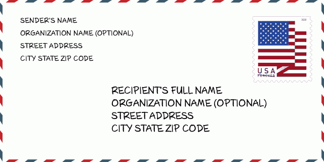
73005-2000 Zarf Örneği

-
Bu, ABD zarfına bir örnektir. Gönderenin bilgilerini sol üstte ve alıcı bilgilerini sağ altta doldurun. Gerekli bilgiler gönderenin/alıcının tam adı, açık adresi, şehri, eyaleti ve posta kodudur. Alıcı adres bilgileri referansınız için verilmiştir. Genel olarak, 9 basamaklı posta kodunun tam olduğundan emin değilseniz, paketin kaybolmasını önlemek için yalnızca 5 basamaklı posta kodunu girebilirsiniz.
73005-2000 Temel Anlam
-
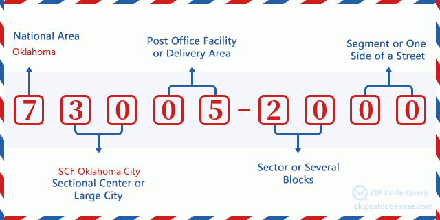
Posta Kodu 73005-2000'in her basamağı ne anlama geliyor? Posta+4 Kodu iki bölümden oluşur, ilk beş basamak postanede bulunabilir ve son dört basamak beş basamaklı teslimat alanı içindeki bir coğrafi segmenti tanımlayabilir. 6-7 basamak, sektörü veya birkaç bloğu belirtir ve 8-9 basamak, bir sokağın segmentini veya bir tarafını belirtir.

- ·Taşıyıcı Rota ID?
A 4-digit code assigned to a mail delivery or collection route within a 5-digit ZIP Code. The first character of this identification is alphabetical, and the last three are numeric: Bnnn = PO box Hnnn = Highway contract Rnnn = Rural route Cnnn = City delivery Gnnn = General delivery: R001 (Kırsal rota)
- ·ZIP Eklenti Düşük Sektör?
The ZIP Add-On Low Sector and the ZIP Add-On Low Segment together form the ZIP Add-On Low Number. The ZIP Add-On Low Number is the last four positions of a ZIP+4 code; the low-end ZIP add-on in a range of codes; the add-on of the first ZIP+4 code in a consecutive series of ZIP+4 codes assigned to the delivery address. For example, most delivery addresses are assigned a single ZIP+4 code. However, large companies may be given a range of ZIP+4 codes that can be used to route mail to specific departments. A range of ZIP+4 codes can also be assigned to a corresponding range of post office boxes, and each box is mapped, one-to-one, with a ZIP+4 code in the range. A single post office box can also be assigned a range of ZIP+4 codes.: 20
- ·ZIP Eklenti Düşük Segment?
The ZIP Add-On Low Sector and the ZIP Add-On Low Segment together form the ZIP Add-On Low Number. The ZIP Add-On Low Number is the last four positions of a ZIP+4 code; the low-end ZIP add-on in a range of codes; the add-on of the first ZIP+4 code in a consecutive series of ZIP+4 codes assigned to the delivery address. For example, most delivery addresses are assigned a single ZIP+4 code. However, large companies may be given a range of ZIP+4 codes that can be used to route mail to specific departments. A range of ZIP+4 codes can also be assigned to a corresponding range of post office boxes, and each box is mapped, one-to-one, with a ZIP+4 code in the range. A single post office box can also be assigned a range of ZIP+4 codes.: 00
- ·ZIP Eklenti Yüksek Sektör?
The ZIP Add-On High Sector and the ZIP Add-On High Segment together form the ZIP Add-On High Number, which is the high-end ZIP add-on in a range of codes; the add-on of the last ZIP+4 code in a consecutive series of ZIP+4 codes assigned to the delivery address. Most delivery addresses are assigned a single ZIP+4 code; however, large companies may be given a range of ZIP+4 codes that can be used to route mail to specific departments. A range of ZIP+4 codes can also be assigned to a corresponding range of post office boxes, and each box is mapped, one-to-one, with a ZIP+4 code in the range. A single post office box can also be assigned a range of ZIP+4 codes. (See also ZIP Add-On Code.): 20
- ·ZIP Eklenti Yüksek Segment?
The ZIP Add-On High Sector and the ZIP Add-On High Segment together form the ZIP Add-On High Number, which is the high-end ZIP add-on in a range of codes; the add-on of the last ZIP+4 code in a consecutive series of ZIP+4 codes assigned to the delivery address. Most delivery addresses are assigned a single ZIP+4 code; however, large companies may be given a range of ZIP+4 codes that can be used to route mail to specific departments. A range of ZIP+4 codes can also be assigned to a corresponding range of post office boxes, and each box is mapped, one-to-one, with a ZIP+4 code in the range. A single post office box can also be assigned a range of ZIP+4 codes. (See also ZIP Add-On Code.): 00
- ·Posta Kodu Eklenti: 2000
- ·Dizi?
The range of +4 codes. Summing the +4 Code and the +4 Range will give you the high end of the range of +4 Codes that pertain to this ZIP Code.: 0
- ·Taban Alternatif Kod?
Code that specifies whether a record is a base (preferred) or alternate record. Base records (represented as "B") can represent a range of addresses or an individual address, such as a firm record, while alternate records (represented as "A") are individual delivery points. Government deliveries will only be listed on alternate records with the appropriate government building indicator (federal, state, or city) set.: Temel
- ·Finans Numarası?
A code assigned to Postal Service facilities (primarily post offices) to collect cost and statistical data and compile revenue and expense data. The state number comprises the first two positions of the finance number.: 390297
- ·Kongre Bölge Numarası?
A standard value identifying a geographic area within the United States served by a member of the US House of Representatives or Senate. If Army/Air Force (APO) or fleet post office (FPO), this column will be blank. If there is only one member of Congress within a state, the code will be "AL" (at large).: 03
- ·Tercih Edilen Son Hat Şehir Durum Anahtarı?
An index to the City State file that provides the preferred last-line name for this address range.: W21836
Çevrimiçi Harita

Bu 18100 COUNTY ROAD 1330 ANADARKO adresinin çevrimiçi haritasıdır. Hareket ettirmek ve yakınlaştırmak / uzaklaştırmak için düğmeyi kullanabilirsiniz. Harita bilgisi sadece referans içindir.
Adres: 18100 (From 18100 To 18199) COUNTY ROAD 1330, ANADARKO, OK 73005-2000, USA
Yorum


Yeni yorum ekle