ที่อยู่: 2300 (From 2300 To 2399) COUNTY STREET 2965, BLANCHARD, OK 73010-3635, USA
73010-3635คืออะไร 73010-3635 เป็นรหัสไปรษณีย์ห้าบวกสี่หลัก 2300 (From 2300 To 2399) COUNTY STREET 2965, BLANCHARD, OK, USA มีรายละเอียดดังต่อไปนี้
73010-3635 ข้อมูลพื้นฐาน

-
รหัสไปรษณีย์ 5 พลัส 4:
73010-3635 -
รหัสไปรษณีย์ 5:
73010 -
พลัส 4?36354-digits that are used to identify a geographic segment within the 5-digit delivery area, such as a city block or a group of apartments or an individual high-volume receiver of mail, or any other unit that could use an extra identifier to aid in efficient mail sorting and delivery. This code is the low end of the range of +4 Codes that pertain to this ZIP Code. ZIP+4 Codes associated with nondelivery areas are composed of valid ZIP sector numbers and "ND" for the ZIP segment number, for example 12345-12ND. Non-deliverable areas are areas to which the USPS does not deliver mail, such as vacant lots and land that borders railroad tracks. Mailers should not match an address identified as a nondelivery area. If you absolutely must have numeric characters in the Plus4Code column, you may treat "ND" values as "00" (zero zero).:
-
ประเทศ:
U.S. - ประเทศสหรัฐอเมริกา -
รัฐ:
OK - โอกลาโฮมา -
อำเภอ:
CountyFIPS: 40051 - Grady County -
เมือง:
BLANCHARD -
ถนน?COUNTY STREET 2965The official name of a street as assigned by a local governing authority. The Street Name column contains only the street name and does not include directionals (EAST, WEST, etc.) or suffixes (ST, DR, BLVD, etc.). This element may also contain literals, such as PO BOX, GENERAL DELIVERY, USS, PSC, or UNIT. Numeric street names that have numeric components that are four characters (or less) in length at are justified such that the low-order digit of the number is positioned in the fourth position of the street name column. This shift is made so that the numeric street names appear in numeric sequence.:
-
ประเภทระเบียน?S: ถนนAn alphabetic value that identifies the type of data in the record. Record type codes include the following: G = General delivery H = Highrise F = Firm S = Street P = PO box R = Rural route/highway contract:
ที่อยู่

- ตัวเลขหลักต่ำของที่อยู่หลัก?
A house, rural route, highway contract box, or post office box number; the numeric or alphanumeric component of an address preceding the street name; the low-end address in a range of addresses. Often referred to as house number.: 2300
- ตัวเลขหลักสูงของที่อยู่หลัก?
A house, rural route, contract box, or Post Office box number. The numeric or alphanumeric component of an address preceding the street name. The high-end address in a range of addresses. Often referred to as house number.: 2399
- เลขคี่ / เลขคู่ที่อยู่หลัก?
Code that identifies the side or sides of a street for which a given address range is applicable. For street, highrise, firm and multi-carrier records, B = Both sides of a street, E = Even side of a street (even-numbered addresses in the range); O = Odd side of a street (odd-numbered addresses in the range). For general delivery, post office box, and rural route/highway contract records, this code will always be "B" (both).: Both of Odd and Even
- หลัก เทือกเขา: 2300, 2301, 2302, 2303, 2304, 2305, 2306, 2307, 2308, 2309, 2310, 2311, 2312, 2313, 2314, 2315, 2316, 2317, 2318, 2319, 2320, 2321, 2322, 2323, 2324, 2325, 2326, 2327, 2328, 2329, 2330, 2331, 2332, 2333, 2334, 2335, 2336, 2337, 2338, 2339, 2340, 2341, 2342, 2343, 2344, 2345, 2346, 2347, 2348, 2349, 2350, 2351, 2352, 2353, 2354, 2355, 2356, 2357, 2358, 2359, 2360, 2361, 2362, 2363, 2364, 2365, 2366, 2367, 2368, 2369, 2370, 2371, 2372, 2373, 2374, 2375, 2376, 2377, 2378, 2379, 2380, 2381, 2382, 2383, 2384, 2385, 2386, 2387, 2388, 2389, 2390, 2391, 2392, 2393, 2394, 2395, 2396, 2397, 2398, 2399.
โปรดคลิก "ตัวอย่างที่อยู่เพิ่มเติม" เพื่อดูรายการทั้งหมด
2300 COUNTY STREET 2965, BLANCHARD, OK 73010-3635
2301 COUNTY STREET 2965, BLANCHARD, OK 73010-3635
2302 COUNTY STREET 2965, BLANCHARD, OK 73010-3635
2303 COUNTY STREET 2965, BLANCHARD, OK 73010-3635
2304 COUNTY STREET 2965, BLANCHARD, OK 73010-3635
2305 COUNTY STREET 2965, BLANCHARD, OK 73010-3635
2306 COUNTY STREET 2965, BLANCHARD, OK 73010-3635
2307 COUNTY STREET 2965, BLANCHARD, OK 73010-3635
2308 COUNTY STREET 2965, BLANCHARD, OK 73010-3635
2309 COUNTY STREET 2965, BLANCHARD, OK 73010-3635
2310 COUNTY STREET 2965, BLANCHARD, OK 73010-3635
2311 COUNTY STREET 2965, BLANCHARD, OK 73010-3635
2312 COUNTY STREET 2965, BLANCHARD, OK 73010-3635
2313 COUNTY STREET 2965, BLANCHARD, OK 73010-3635
2314 COUNTY STREET 2965, BLANCHARD, OK 73010-3635
2315 COUNTY STREET 2965, BLANCHARD, OK 73010-3635
2316 COUNTY STREET 2965, BLANCHARD, OK 73010-3635
2317 COUNTY STREET 2965, BLANCHARD, OK 73010-3635
2318 COUNTY STREET 2965, BLANCHARD, OK 73010-3635
2319 COUNTY STREET 2965, BLANCHARD, OK 73010-3635
2320 COUNTY STREET 2965, BLANCHARD, OK 73010-3635
2321 COUNTY STREET 2965, BLANCHARD, OK 73010-3635
2322 COUNTY STREET 2965, BLANCHARD, OK 73010-3635
2323 COUNTY STREET 2965, BLANCHARD, OK 73010-3635
2324 COUNTY STREET 2965, BLANCHARD, OK 73010-3635
2325 COUNTY STREET 2965, BLANCHARD, OK 73010-3635
2326 COUNTY STREET 2965, BLANCHARD, OK 73010-3635
2327 COUNTY STREET 2965, BLANCHARD, OK 73010-3635
2328 COUNTY STREET 2965, BLANCHARD, OK 73010-3635
2329 COUNTY STREET 2965, BLANCHARD, OK 73010-3635
2330 COUNTY STREET 2965, BLANCHARD, OK 73010-3635
2331 COUNTY STREET 2965, BLANCHARD, OK 73010-3635
2332 COUNTY STREET 2965, BLANCHARD, OK 73010-3635
2333 COUNTY STREET 2965, BLANCHARD, OK 73010-3635
2334 COUNTY STREET 2965, BLANCHARD, OK 73010-3635
2335 COUNTY STREET 2965, BLANCHARD, OK 73010-3635
2336 COUNTY STREET 2965, BLANCHARD, OK 73010-3635
2337 COUNTY STREET 2965, BLANCHARD, OK 73010-3635
2338 COUNTY STREET 2965, BLANCHARD, OK 73010-3635
2339 COUNTY STREET 2965, BLANCHARD, OK 73010-3635
2340 COUNTY STREET 2965, BLANCHARD, OK 73010-3635
2341 COUNTY STREET 2965, BLANCHARD, OK 73010-3635
2342 COUNTY STREET 2965, BLANCHARD, OK 73010-3635
2343 COUNTY STREET 2965, BLANCHARD, OK 73010-3635
2344 COUNTY STREET 2965, BLANCHARD, OK 73010-3635
2345 COUNTY STREET 2965, BLANCHARD, OK 73010-3635
2346 COUNTY STREET 2965, BLANCHARD, OK 73010-3635
2347 COUNTY STREET 2965, BLANCHARD, OK 73010-3635
2348 COUNTY STREET 2965, BLANCHARD, OK 73010-3635
2349 COUNTY STREET 2965, BLANCHARD, OK 73010-3635
2350 COUNTY STREET 2965, BLANCHARD, OK 73010-3635
2351 COUNTY STREET 2965, BLANCHARD, OK 73010-3635
2352 COUNTY STREET 2965, BLANCHARD, OK 73010-3635
2353 COUNTY STREET 2965, BLANCHARD, OK 73010-3635
2354 COUNTY STREET 2965, BLANCHARD, OK 73010-3635
2355 COUNTY STREET 2965, BLANCHARD, OK 73010-3635
2356 COUNTY STREET 2965, BLANCHARD, OK 73010-3635
2357 COUNTY STREET 2965, BLANCHARD, OK 73010-3635
2358 COUNTY STREET 2965, BLANCHARD, OK 73010-3635
2359 COUNTY STREET 2965, BLANCHARD, OK 73010-3635
2360 COUNTY STREET 2965, BLANCHARD, OK 73010-3635
2361 COUNTY STREET 2965, BLANCHARD, OK 73010-3635
2362 COUNTY STREET 2965, BLANCHARD, OK 73010-3635
2363 COUNTY STREET 2965, BLANCHARD, OK 73010-3635
2364 COUNTY STREET 2965, BLANCHARD, OK 73010-3635
2365 COUNTY STREET 2965, BLANCHARD, OK 73010-3635
2366 COUNTY STREET 2965, BLANCHARD, OK 73010-3635
2367 COUNTY STREET 2965, BLANCHARD, OK 73010-3635
2368 COUNTY STREET 2965, BLANCHARD, OK 73010-3635
2369 COUNTY STREET 2965, BLANCHARD, OK 73010-3635
2370 COUNTY STREET 2965, BLANCHARD, OK 73010-3635
2371 COUNTY STREET 2965, BLANCHARD, OK 73010-3635
2372 COUNTY STREET 2965, BLANCHARD, OK 73010-3635
2373 COUNTY STREET 2965, BLANCHARD, OK 73010-3635
2374 COUNTY STREET 2965, BLANCHARD, OK 73010-3635
2375 COUNTY STREET 2965, BLANCHARD, OK 73010-3635
2376 COUNTY STREET 2965, BLANCHARD, OK 73010-3635
2377 COUNTY STREET 2965, BLANCHARD, OK 73010-3635
2378 COUNTY STREET 2965, BLANCHARD, OK 73010-3635
2379 COUNTY STREET 2965, BLANCHARD, OK 73010-3635
2380 COUNTY STREET 2965, BLANCHARD, OK 73010-3635
2381 COUNTY STREET 2965, BLANCHARD, OK 73010-3635
2382 COUNTY STREET 2965, BLANCHARD, OK 73010-3635
2383 COUNTY STREET 2965, BLANCHARD, OK 73010-3635
2384 COUNTY STREET 2965, BLANCHARD, OK 73010-3635
2385 COUNTY STREET 2965, BLANCHARD, OK 73010-3635
2386 COUNTY STREET 2965, BLANCHARD, OK 73010-3635
2387 COUNTY STREET 2965, BLANCHARD, OK 73010-3635
2388 COUNTY STREET 2965, BLANCHARD, OK 73010-3635
2389 COUNTY STREET 2965, BLANCHARD, OK 73010-3635
2390 COUNTY STREET 2965, BLANCHARD, OK 73010-3635
2391 COUNTY STREET 2965, BLANCHARD, OK 73010-3635
2392 COUNTY STREET 2965, BLANCHARD, OK 73010-3635
2393 COUNTY STREET 2965, BLANCHARD, OK 73010-3635
2394 COUNTY STREET 2965, BLANCHARD, OK 73010-3635
2395 COUNTY STREET 2965, BLANCHARD, OK 73010-3635
2396 COUNTY STREET 2965, BLANCHARD, OK 73010-3635
2397 COUNTY STREET 2965, BLANCHARD, OK 73010-3635
2398 COUNTY STREET 2965, BLANCHARD, OK 73010-3635
2399 COUNTY STREET 2965, BLANCHARD, OK 73010-3635
ที่อยู่ ตัวอย่าง
BLANCHARD OK 73010-3635
UNITED STATES OF AMERICA
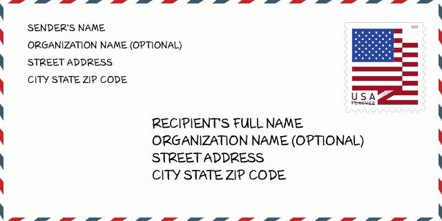
73010-3635 ตัวอย่างซองจดหมาย

-
นี่คือตัวอย่างซองจดหมายของสหรัฐฯ กรอกข้อมูลผู้ส่งที่ด้านบนซ้ายและข้อมูลผู้รับที่ด้านล่างขวา ข้อมูลที่จำเป็นคือชื่อเต็มของผู้ส่ง/ผู้รับ ที่อยู่ เมือง รัฐ และรหัสไปรษณีย์ ข้อมูลที่อยู่ผู้รับได้รับสำหรับการอ้างอิงของคุณ โดยทั่วไป หากคุณไม่แน่ใจเกี่ยวกับรหัสไปรษณีย์ 9 หลักแบบเต็ม คุณสามารถกรอกรหัสไปรษณีย์ 5 หลักเท่านั้นเพื่อหลีกเลี่ยงการสูญหายของพัสดุ
73010-3635 ความหมายพื้นฐาน
-
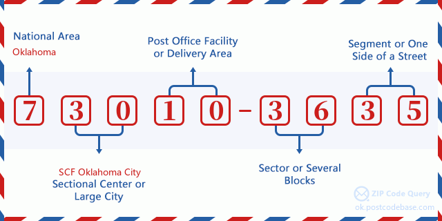
รหัสไปรษณีย์ 73010-3635 แต่ละหลักย่อมาจากอะไร ? รหัสไปรษณีย์ประกอบด้วยสองส่วน โดยสามารถระบุหมายเลขห้าหลักแรกไปยังที่ทำการไปรษณีย์ได้ และตัวเลขสี่หลักสุดท้ายสามารถระบุส่วนทางภูมิศาสตร์ภายในพื้นที่จัดส่งห้าหลักได้ ตัวเลข 6-7 หลักกำหนดส่วนหรือหลายช่วงตึก และตัวเลข 8-9 หลักกำหนดส่วนหรือด้านใดด้านหนึ่งของถนน

- · Idเส้นทางการขนส่ง?
A 4-digit code assigned to a mail delivery or collection route within a 5-digit ZIP Code. The first character of this identification is alphabetical, and the last three are numeric: Bnnn = PO box Hnnn = Highway contract Rnnn = Rural route Cnnn = City delivery Gnnn = General delivery: R003 (สายชนบท)
- ·ภาคต่ำเพิ่มเติมทางไปรษณีย์?
The ZIP Add-On Low Sector and the ZIP Add-On Low Segment together form the ZIP Add-On Low Number. The ZIP Add-On Low Number is the last four positions of a ZIP+4 code; the low-end ZIP add-on in a range of codes; the add-on of the first ZIP+4 code in a consecutive series of ZIP+4 codes assigned to the delivery address. For example, most delivery addresses are assigned a single ZIP+4 code. However, large companies may be given a range of ZIP+4 codes that can be used to route mail to specific departments. A range of ZIP+4 codes can also be assigned to a corresponding range of post office boxes, and each box is mapped, one-to-one, with a ZIP+4 code in the range. A single post office box can also be assigned a range of ZIP+4 codes.: 36
- ·ส่วนต่ำเพิ่มเติมทางไปรษณีย์?
The ZIP Add-On Low Sector and the ZIP Add-On Low Segment together form the ZIP Add-On Low Number. The ZIP Add-On Low Number is the last four positions of a ZIP+4 code; the low-end ZIP add-on in a range of codes; the add-on of the first ZIP+4 code in a consecutive series of ZIP+4 codes assigned to the delivery address. For example, most delivery addresses are assigned a single ZIP+4 code. However, large companies may be given a range of ZIP+4 codes that can be used to route mail to specific departments. A range of ZIP+4 codes can also be assigned to a corresponding range of post office boxes, and each box is mapped, one-to-one, with a ZIP+4 code in the range. A single post office box can also be assigned a range of ZIP+4 codes.: 35
- ·ภาคสูงเพิ่มเติมทางไปรษณีย์?
The ZIP Add-On High Sector and the ZIP Add-On High Segment together form the ZIP Add-On High Number, which is the high-end ZIP add-on in a range of codes; the add-on of the last ZIP+4 code in a consecutive series of ZIP+4 codes assigned to the delivery address. Most delivery addresses are assigned a single ZIP+4 code; however, large companies may be given a range of ZIP+4 codes that can be used to route mail to specific departments. A range of ZIP+4 codes can also be assigned to a corresponding range of post office boxes, and each box is mapped, one-to-one, with a ZIP+4 code in the range. A single post office box can also be assigned a range of ZIP+4 codes. (See also ZIP Add-On Code.): 36
- ·ส่วนสูงเพิ่มเติมทางไปรษณีย์?
The ZIP Add-On High Sector and the ZIP Add-On High Segment together form the ZIP Add-On High Number, which is the high-end ZIP add-on in a range of codes; the add-on of the last ZIP+4 code in a consecutive series of ZIP+4 codes assigned to the delivery address. Most delivery addresses are assigned a single ZIP+4 code; however, large companies may be given a range of ZIP+4 codes that can be used to route mail to specific departments. A range of ZIP+4 codes can also be assigned to a corresponding range of post office boxes, and each box is mapped, one-to-one, with a ZIP+4 code in the range. A single post office box can also be assigned a range of ZIP+4 codes. (See also ZIP Add-On Code.): 35
- ·รหัสไปรษณีย์ เพิ่มเติม: 3635
- ·เทือกเขา?
The range of +4 codes. Summing the +4 Code and the +4 Range will give you the high end of the range of +4 Codes that pertain to this ZIP Code.: 0
- ·รหัสแทนขั้นพื้นฐาน?
Code that specifies whether a record is a base (preferred) or alternate record. Base records (represented as "B") can represent a range of addresses or an individual address, such as a firm record, while alternate records (represented as "A") are individual delivery points. Government deliveries will only be listed on alternate records with the appropriate government building indicator (federal, state, or city) set.: พื้นฐาน
- ·ตัวเลขทางการเงิน?
A code assigned to Postal Service facilities (primarily post offices) to collect cost and statistical data and compile revenue and expense data. The state number comprises the first two positions of the finance number.: 390825
- ·ตัวเลขแขวงรัฐสภา?
A standard value identifying a geographic area within the United States served by a member of the US House of Representatives or Senate. If Army/Air Force (APO) or fleet post office (FPO), this column will be blank. If there is only one member of Congress within a state, the code will be "AL" (at large).: 04
- ·รหัสรัฐเมืองบรรทัดสุดท้าย?
An index to the City State file that provides the preferred last-line name for this address range.: W21875
แผนที่ออนไลน์

นี่คือแผนที่อิเล็กทรอนิกส์ออนไลน์ที่ที่อยู่ 2300 COUNTY STREET 2965 BLANCHARDจับคู่นั้น คุณสามารถจะใช้ปุ่มบนแผนที่เพื่อเลื่อนและซูม ข้อมูลแผนที่นี้ เฉพาะสำหรับการอ้างอิงเท่านั้น
ที่อยู่: 2300 (From 2300 To 2399) COUNTY STREET 2965, BLANCHARD, OK 73010-3635, USA
ความเห็น


แสดงความเห็น