Endereço: 256800 (From 256800 To 256899) E (East) COUNTY ROAD 880, GREENFIELD, OK 73043-0019, USA
O que é o 73043-0019? 73043-0019 é um número de CEP 5 Plus 4 de 256800 (From 256800 To 256899) E (East) COUNTY ROAD 880, GREENFIELD, OK, USA. Abaixo estão as informações detalhadas.
73043-0019 Informação básica

-
CEP 5 mais 4:
73043-0019 -
CEP 5:
73043 -
Mais 4?00194-digits that are used to identify a geographic segment within the 5-digit delivery area, such as a city block or a group of apartments or an individual high-volume receiver of mail, or any other unit that could use an extra identifier to aid in efficient mail sorting and delivery. This code is the low end of the range of +4 Codes that pertain to this ZIP Code. ZIP+4 Codes associated with nondelivery areas are composed of valid ZIP sector numbers and "ND" for the ZIP segment number, for example 12345-12ND. Non-deliverable areas are areas to which the USPS does not deliver mail, such as vacant lots and land that borders railroad tracks. Mailers should not match an address identified as a nondelivery area. If you absolutely must have numeric characters in the Plus4Code column, you may treat "ND" values as "00" (zero zero).:
-
País:
U.S. - United States -
Estado:
OK - Oklahoma -
Condado:
CountyFIPS: 40011 - Blaine County -
Cidade:
GREENFIELD -
Street Predirectional:
E (East) -
Rua?COUNTY ROAD 880The official name of a street as assigned by a local governing authority. The Street Name column contains only the street name and does not include directionals (EAST, WEST, etc.) or suffixes (ST, DR, BLVD, etc.). This element may also contain literals, such as PO BOX, GENERAL DELIVERY, USS, PSC, or UNIT. Numeric street names that have numeric components that are four characters (or less) in length at are justified such that the low-order digit of the number is positioned in the fourth position of the street name column. This shift is made so that the numeric street names appear in numeric sequence.:
-
Tipo de Registro?S: RuaAn alphabetic value that identifies the type of data in the record. Record type codes include the following: G = General delivery H = Highrise F = Firm S = Street P = PO box R = Rural route/highway contract:
Endereço

- Endereço de número baixo primário?
A house, rural route, highway contract box, or post office box number; the numeric or alphanumeric component of an address preceding the street name; the low-end address in a range of addresses. Often referred to as house number.: 256800
- Endereço Primário Número Alto?
A house, rural route, contract box, or Post Office box number. The numeric or alphanumeric component of an address preceding the street name. The high-end address in a range of addresses. Often referred to as house number.: 256899
- Endereço do código ímpar / par primário?
Code that identifies the side or sides of a street for which a given address range is applicable. For street, highrise, firm and multi-carrier records, B = Both sides of a street, E = Even side of a street (even-numbered addresses in the range); O = Odd side of a street (odd-numbered addresses in the range). For general delivery, post office box, and rural route/highway contract records, this code will always be "B" (both).: Both of Odd and Even
- Primário Faixa: 256800, 256801, 256802, 256803, 256804, 256805, 256806, 256807, 256808, 256809, 256810, 256811, 256812, 256813, 256814, 256815, 256816, 256817, 256818, 256819, 256820, 256821, 256822, 256823, 256824, 256825, 256826, 256827, 256828, 256829, 256830, 256831, 256832, 256833, 256834, 256835, 256836, 256837, 256838, 256839, 256840, 256841, 256842, 256843, 256844, 256845, 256846, 256847, 256848, 256849, 256850, 256851, 256852, 256853, 256854, 256855, 256856, 256857, 256858, 256859, 256860, 256861, 256862, 256863, 256864, 256865, 256866, 256867, 256868, 256869, 256870, 256871, 256872, 256873, 256874, 256875, 256876, 256877, 256878, 256879, 256880, 256881, 256882, 256883, 256884, 256885, 256886, 256887, 256888, 256889, 256890, 256891, 256892, 256893, 256894, 256895, 256896, 256897, 256898, 256899.
Clique no "Mais exemplos de endereços" para ver a lista completa.
256800 E (East) COUNTY ROAD 880, GREENFIELD, OK 73043-0019
256801 E (East) COUNTY ROAD 880, GREENFIELD, OK 73043-0019
256802 E (East) COUNTY ROAD 880, GREENFIELD, OK 73043-0019
256803 E (East) COUNTY ROAD 880, GREENFIELD, OK 73043-0019
256804 E (East) COUNTY ROAD 880, GREENFIELD, OK 73043-0019
256805 E (East) COUNTY ROAD 880, GREENFIELD, OK 73043-0019
256806 E (East) COUNTY ROAD 880, GREENFIELD, OK 73043-0019
256807 E (East) COUNTY ROAD 880, GREENFIELD, OK 73043-0019
256808 E (East) COUNTY ROAD 880, GREENFIELD, OK 73043-0019
256809 E (East) COUNTY ROAD 880, GREENFIELD, OK 73043-0019
256810 E (East) COUNTY ROAD 880, GREENFIELD, OK 73043-0019
256811 E (East) COUNTY ROAD 880, GREENFIELD, OK 73043-0019
256812 E (East) COUNTY ROAD 880, GREENFIELD, OK 73043-0019
256813 E (East) COUNTY ROAD 880, GREENFIELD, OK 73043-0019
256814 E (East) COUNTY ROAD 880, GREENFIELD, OK 73043-0019
256815 E (East) COUNTY ROAD 880, GREENFIELD, OK 73043-0019
256816 E (East) COUNTY ROAD 880, GREENFIELD, OK 73043-0019
256817 E (East) COUNTY ROAD 880, GREENFIELD, OK 73043-0019
256818 E (East) COUNTY ROAD 880, GREENFIELD, OK 73043-0019
256819 E (East) COUNTY ROAD 880, GREENFIELD, OK 73043-0019
256820 E (East) COUNTY ROAD 880, GREENFIELD, OK 73043-0019
256821 E (East) COUNTY ROAD 880, GREENFIELD, OK 73043-0019
256822 E (East) COUNTY ROAD 880, GREENFIELD, OK 73043-0019
256823 E (East) COUNTY ROAD 880, GREENFIELD, OK 73043-0019
256824 E (East) COUNTY ROAD 880, GREENFIELD, OK 73043-0019
256825 E (East) COUNTY ROAD 880, GREENFIELD, OK 73043-0019
256826 E (East) COUNTY ROAD 880, GREENFIELD, OK 73043-0019
256827 E (East) COUNTY ROAD 880, GREENFIELD, OK 73043-0019
256828 E (East) COUNTY ROAD 880, GREENFIELD, OK 73043-0019
256829 E (East) COUNTY ROAD 880, GREENFIELD, OK 73043-0019
256830 E (East) COUNTY ROAD 880, GREENFIELD, OK 73043-0019
256831 E (East) COUNTY ROAD 880, GREENFIELD, OK 73043-0019
256832 E (East) COUNTY ROAD 880, GREENFIELD, OK 73043-0019
256833 E (East) COUNTY ROAD 880, GREENFIELD, OK 73043-0019
256834 E (East) COUNTY ROAD 880, GREENFIELD, OK 73043-0019
256835 E (East) COUNTY ROAD 880, GREENFIELD, OK 73043-0019
256836 E (East) COUNTY ROAD 880, GREENFIELD, OK 73043-0019
256837 E (East) COUNTY ROAD 880, GREENFIELD, OK 73043-0019
256838 E (East) COUNTY ROAD 880, GREENFIELD, OK 73043-0019
256839 E (East) COUNTY ROAD 880, GREENFIELD, OK 73043-0019
256840 E (East) COUNTY ROAD 880, GREENFIELD, OK 73043-0019
256841 E (East) COUNTY ROAD 880, GREENFIELD, OK 73043-0019
256842 E (East) COUNTY ROAD 880, GREENFIELD, OK 73043-0019
256843 E (East) COUNTY ROAD 880, GREENFIELD, OK 73043-0019
256844 E (East) COUNTY ROAD 880, GREENFIELD, OK 73043-0019
256845 E (East) COUNTY ROAD 880, GREENFIELD, OK 73043-0019
256846 E (East) COUNTY ROAD 880, GREENFIELD, OK 73043-0019
256847 E (East) COUNTY ROAD 880, GREENFIELD, OK 73043-0019
256848 E (East) COUNTY ROAD 880, GREENFIELD, OK 73043-0019
256849 E (East) COUNTY ROAD 880, GREENFIELD, OK 73043-0019
256850 E (East) COUNTY ROAD 880, GREENFIELD, OK 73043-0019
256851 E (East) COUNTY ROAD 880, GREENFIELD, OK 73043-0019
256852 E (East) COUNTY ROAD 880, GREENFIELD, OK 73043-0019
256853 E (East) COUNTY ROAD 880, GREENFIELD, OK 73043-0019
256854 E (East) COUNTY ROAD 880, GREENFIELD, OK 73043-0019
256855 E (East) COUNTY ROAD 880, GREENFIELD, OK 73043-0019
256856 E (East) COUNTY ROAD 880, GREENFIELD, OK 73043-0019
256857 E (East) COUNTY ROAD 880, GREENFIELD, OK 73043-0019
256858 E (East) COUNTY ROAD 880, GREENFIELD, OK 73043-0019
256859 E (East) COUNTY ROAD 880, GREENFIELD, OK 73043-0019
256860 E (East) COUNTY ROAD 880, GREENFIELD, OK 73043-0019
256861 E (East) COUNTY ROAD 880, GREENFIELD, OK 73043-0019
256862 E (East) COUNTY ROAD 880, GREENFIELD, OK 73043-0019
256863 E (East) COUNTY ROAD 880, GREENFIELD, OK 73043-0019
256864 E (East) COUNTY ROAD 880, GREENFIELD, OK 73043-0019
256865 E (East) COUNTY ROAD 880, GREENFIELD, OK 73043-0019
256866 E (East) COUNTY ROAD 880, GREENFIELD, OK 73043-0019
256867 E (East) COUNTY ROAD 880, GREENFIELD, OK 73043-0019
256868 E (East) COUNTY ROAD 880, GREENFIELD, OK 73043-0019
256869 E (East) COUNTY ROAD 880, GREENFIELD, OK 73043-0019
256870 E (East) COUNTY ROAD 880, GREENFIELD, OK 73043-0019
256871 E (East) COUNTY ROAD 880, GREENFIELD, OK 73043-0019
256872 E (East) COUNTY ROAD 880, GREENFIELD, OK 73043-0019
256873 E (East) COUNTY ROAD 880, GREENFIELD, OK 73043-0019
256874 E (East) COUNTY ROAD 880, GREENFIELD, OK 73043-0019
256875 E (East) COUNTY ROAD 880, GREENFIELD, OK 73043-0019
256876 E (East) COUNTY ROAD 880, GREENFIELD, OK 73043-0019
256877 E (East) COUNTY ROAD 880, GREENFIELD, OK 73043-0019
256878 E (East) COUNTY ROAD 880, GREENFIELD, OK 73043-0019
256879 E (East) COUNTY ROAD 880, GREENFIELD, OK 73043-0019
256880 E (East) COUNTY ROAD 880, GREENFIELD, OK 73043-0019
256881 E (East) COUNTY ROAD 880, GREENFIELD, OK 73043-0019
256882 E (East) COUNTY ROAD 880, GREENFIELD, OK 73043-0019
256883 E (East) COUNTY ROAD 880, GREENFIELD, OK 73043-0019
256884 E (East) COUNTY ROAD 880, GREENFIELD, OK 73043-0019
256885 E (East) COUNTY ROAD 880, GREENFIELD, OK 73043-0019
256886 E (East) COUNTY ROAD 880, GREENFIELD, OK 73043-0019
256887 E (East) COUNTY ROAD 880, GREENFIELD, OK 73043-0019
256888 E (East) COUNTY ROAD 880, GREENFIELD, OK 73043-0019
256889 E (East) COUNTY ROAD 880, GREENFIELD, OK 73043-0019
256890 E (East) COUNTY ROAD 880, GREENFIELD, OK 73043-0019
256891 E (East) COUNTY ROAD 880, GREENFIELD, OK 73043-0019
256892 E (East) COUNTY ROAD 880, GREENFIELD, OK 73043-0019
256893 E (East) COUNTY ROAD 880, GREENFIELD, OK 73043-0019
256894 E (East) COUNTY ROAD 880, GREENFIELD, OK 73043-0019
256895 E (East) COUNTY ROAD 880, GREENFIELD, OK 73043-0019
256896 E (East) COUNTY ROAD 880, GREENFIELD, OK 73043-0019
256897 E (East) COUNTY ROAD 880, GREENFIELD, OK 73043-0019
256898 E (East) COUNTY ROAD 880, GREENFIELD, OK 73043-0019
256899 E (East) COUNTY ROAD 880, GREENFIELD, OK 73043-0019
Endereço Exemplo
GREENFIELD OK 73043-0019
UNITED STATES OF AMERICA
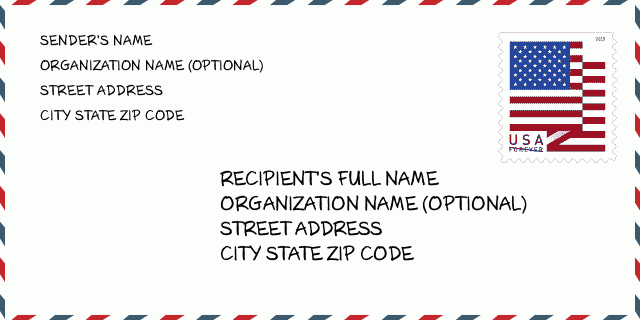
73043-0019 Exemplo de envelope

-
Este é um exemplo de envelope americano. Preencha as informações do remetente no canto superior esquerdo e as informações do destinatário no canto inferior direito. As informações necessárias são o nome completo do remetente / destinatário, endereço, cidade, estado e código postal. As informações do endereço do destinatário foram fornecidas para sua referência. Geralmente, se você não tiver certeza do código postal de 9 dígitos completo, só poderá preencher o código postal de 5 dígitos para evitar a perda do pacote.
73043-0019 Significado Básico
-
O que cada dígito do CEP 73043-0019 representa? O código ZIP + 4 consiste em duas partes, os primeiros cinco dígitos podem ser localizados na agência dos correios e os últimos quatro dígitos podem identificar um segmento geográfico dentro da área de entrega de cinco dígitos. Os 6 a 7 dígitos designam o setor ou vários blocos, e os 8 a 9 dígitos designam o segmento ou um lado de uma rua.
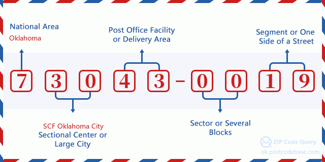

- ·ID da rota da transportadora?
A 4-digit code assigned to a mail delivery or collection route within a 5-digit ZIP Code. The first character of this identification is alphabetical, and the last three are numeric: Bnnn = PO box Hnnn = Highway contract Rnnn = Rural route Cnnn = City delivery Gnnn = General delivery: R001 (Rural route)
- ·Setor baixo do complemento ZIP?
The ZIP Add-On Low Sector and the ZIP Add-On Low Segment together form the ZIP Add-On Low Number. The ZIP Add-On Low Number is the last four positions of a ZIP+4 code; the low-end ZIP add-on in a range of codes; the add-on of the first ZIP+4 code in a consecutive series of ZIP+4 codes assigned to the delivery address. For example, most delivery addresses are assigned a single ZIP+4 code. However, large companies may be given a range of ZIP+4 codes that can be used to route mail to specific departments. A range of ZIP+4 codes can also be assigned to a corresponding range of post office boxes, and each box is mapped, one-to-one, with a ZIP+4 code in the range. A single post office box can also be assigned a range of ZIP+4 codes.: 00
- ·Segmento baixo do complemento ZIP?
The ZIP Add-On Low Sector and the ZIP Add-On Low Segment together form the ZIP Add-On Low Number. The ZIP Add-On Low Number is the last four positions of a ZIP+4 code; the low-end ZIP add-on in a range of codes; the add-on of the first ZIP+4 code in a consecutive series of ZIP+4 codes assigned to the delivery address. For example, most delivery addresses are assigned a single ZIP+4 code. However, large companies may be given a range of ZIP+4 codes that can be used to route mail to specific departments. A range of ZIP+4 codes can also be assigned to a corresponding range of post office boxes, and each box is mapped, one-to-one, with a ZIP+4 code in the range. A single post office box can also be assigned a range of ZIP+4 codes.: 19
- ·ZIP Add-On High Sector?
The ZIP Add-On High Sector and the ZIP Add-On High Segment together form the ZIP Add-On High Number, which is the high-end ZIP add-on in a range of codes; the add-on of the last ZIP+4 code in a consecutive series of ZIP+4 codes assigned to the delivery address. Most delivery addresses are assigned a single ZIP+4 code; however, large companies may be given a range of ZIP+4 codes that can be used to route mail to specific departments. A range of ZIP+4 codes can also be assigned to a corresponding range of post office boxes, and each box is mapped, one-to-one, with a ZIP+4 code in the range. A single post office box can also be assigned a range of ZIP+4 codes. (See also ZIP Add-On Code.): 00
- ·Complemento ZIP de alto segmento?
The ZIP Add-On High Sector and the ZIP Add-On High Segment together form the ZIP Add-On High Number, which is the high-end ZIP add-on in a range of codes; the add-on of the last ZIP+4 code in a consecutive series of ZIP+4 codes assigned to the delivery address. Most delivery addresses are assigned a single ZIP+4 code; however, large companies may be given a range of ZIP+4 codes that can be used to route mail to specific departments. A range of ZIP+4 codes can also be assigned to a corresponding range of post office boxes, and each box is mapped, one-to-one, with a ZIP+4 code in the range. A single post office box can also be assigned a range of ZIP+4 codes. (See also ZIP Add-On Code.): 19
- ·Código Postal Add On: 0019
- ·Faixa?
The range of +4 codes. Summing the +4 Code and the +4 Range will give you the high end of the range of +4 Codes that pertain to this ZIP Code.: 0
- ·Código Alternativo Básico?
Code that specifies whether a record is a base (preferred) or alternate record. Base records (represented as "B") can represent a range of addresses or an individual address, such as a firm record, while alternate records (represented as "A") are individual delivery points. Government deliveries will only be listed on alternate records with the appropriate government building indicator (federal, state, or city) set.: Base
- ·Número Financeiro?
A code assigned to Postal Service facilities (primarily post offices) to collect cost and statistical data and compile revenue and expense data. The state number comprises the first two positions of the finance number.: 393608
- ·Número do distrito congressional?
A standard value identifying a geographic area within the United States served by a member of the US House of Representatives or Senate. If Army/Air Force (APO) or fleet post office (FPO), this column will be blank. If there is only one member of Congress within a state, the code will be "AL" (at large).: 03
- ·Chave de estado da cidade de última linha preferida?
An index to the City State file that provides the preferred last-line name for this address range.: W22115
Mapa Online

Este é o mapa on-line do endereço 256800 E (East) COUNTY ROAD 880 GREENFIELD. Você pode usar o botão para mover e fazer zoom in / out. As informações do mapa são apenas para referência.
Endereço: 256800 (From 256800 To 256899) E (East) COUNTY ROAD 880, GREENFIELD, OK 73043-0019, USA
Comment


Add new comment