주소: 2100 (From 2100 To 2199) COUNTY ROAD 1420, ALEX, OK 73002-2237, USA
73002-2237은 무엇입니까? 73002-2237 2100 (From 2100 To 2199) COUNTY ROAD 1420, ALEX, OK, USA 의 5플러스 4 우편번호입니다. 다음은 세부정보입니다.
73002-2237 기본 정보

-
우편 번호 5 플러스 4:
73002-2237 -
우편 번호 5:
73002 -
플러스 4?22374-digits that are used to identify a geographic segment within the 5-digit delivery area, such as a city block or a group of apartments or an individual high-volume receiver of mail, or any other unit that could use an extra identifier to aid in efficient mail sorting and delivery. This code is the low end of the range of +4 Codes that pertain to this ZIP Code. ZIP+4 Codes associated with nondelivery areas are composed of valid ZIP sector numbers and "ND" for the ZIP segment number, for example 12345-12ND. Non-deliverable areas are areas to which the USPS does not deliver mail, such as vacant lots and land that borders railroad tracks. Mailers should not match an address identified as a nondelivery area. If you absolutely must have numeric characters in the Plus4Code column, you may treat "ND" values as "00" (zero zero).:
-
나라:
U.S. - 미국 -
주:
OK - 오클라호마 -
군:
CountyFIPS: 40051 - Grady County -
도시:
ALEX -
거리?COUNTY ROAD 1420The official name of a street as assigned by a local governing authority. The Street Name column contains only the street name and does not include directionals (EAST, WEST, etc.) or suffixes (ST, DR, BLVD, etc.). This element may also contain literals, such as PO BOX, GENERAL DELIVERY, USS, PSC, or UNIT. Numeric street names that have numeric components that are four characters (or less) in length at are justified such that the low-order digit of the number is positioned in the fourth position of the street name column. This shift is made so that the numeric street names appear in numeric sequence.:
-
기록 유형?S: 거리An alphabetic value that identifies the type of data in the record. Record type codes include the following: G = General delivery H = Highrise F = Firm S = Street P = PO box R = Rural route/highway contract:
주소

- 주요 주소 낮은 수치?
A house, rural route, highway contract box, or post office box number; the numeric or alphanumeric component of an address preceding the street name; the low-end address in a range of addresses. Often referred to as house number.: 2100
- 주요 주소 높은 수치?
A house, rural route, contract box, or Post Office box number. The numeric or alphanumeric component of an address preceding the street name. The high-end address in a range of addresses. Often referred to as house number.: 2199
- 주요 주소 홀수/짝수 코드?
Code that identifies the side or sides of a street for which a given address range is applicable. For street, highrise, firm and multi-carrier records, B = Both sides of a street, E = Even side of a street (even-numbered addresses in the range); O = Odd side of a street (odd-numbered addresses in the range). For general delivery, post office box, and rural route/highway contract records, this code will always be "B" (both).: Both of Odd and Even
- 일 순위 범위: 2100, 2101, 2102, 2103, 2104, 2105, 2106, 2107, 2108, 2109, 2110, 2111, 2112, 2113, 2114, 2115, 2116, 2117, 2118, 2119, 2120, 2121, 2122, 2123, 2124, 2125, 2126, 2127, 2128, 2129, 2130, 2131, 2132, 2133, 2134, 2135, 2136, 2137, 2138, 2139, 2140, 2141, 2142, 2143, 2144, 2145, 2146, 2147, 2148, 2149, 2150, 2151, 2152, 2153, 2154, 2155, 2156, 2157, 2158, 2159, 2160, 2161, 2162, 2163, 2164, 2165, 2166, 2167, 2168, 2169, 2170, 2171, 2172, 2173, 2174, 2175, 2176, 2177, 2178, 2179, 2180, 2181, 2182, 2183, 2184, 2185, 2186, 2187, 2188, 2189, 2190, 2191, 2192, 2193, 2194, 2195, 2196, 2197, 2198, 2199.
전체 목록을 보려면 "더 많은 주소 예시"을 클릭하십시오.
2100 COUNTY ROAD 1420, ALEX, OK 73002-2237
2101 COUNTY ROAD 1420, ALEX, OK 73002-2237
2102 COUNTY ROAD 1420, ALEX, OK 73002-2237
2103 COUNTY ROAD 1420, ALEX, OK 73002-2237
2104 COUNTY ROAD 1420, ALEX, OK 73002-2237
2105 COUNTY ROAD 1420, ALEX, OK 73002-2237
2106 COUNTY ROAD 1420, ALEX, OK 73002-2237
2107 COUNTY ROAD 1420, ALEX, OK 73002-2237
2108 COUNTY ROAD 1420, ALEX, OK 73002-2237
2109 COUNTY ROAD 1420, ALEX, OK 73002-2237
2110 COUNTY ROAD 1420, ALEX, OK 73002-2237
2111 COUNTY ROAD 1420, ALEX, OK 73002-2237
2112 COUNTY ROAD 1420, ALEX, OK 73002-2237
2113 COUNTY ROAD 1420, ALEX, OK 73002-2237
2114 COUNTY ROAD 1420, ALEX, OK 73002-2237
2115 COUNTY ROAD 1420, ALEX, OK 73002-2237
2116 COUNTY ROAD 1420, ALEX, OK 73002-2237
2117 COUNTY ROAD 1420, ALEX, OK 73002-2237
2118 COUNTY ROAD 1420, ALEX, OK 73002-2237
2119 COUNTY ROAD 1420, ALEX, OK 73002-2237
2120 COUNTY ROAD 1420, ALEX, OK 73002-2237
2121 COUNTY ROAD 1420, ALEX, OK 73002-2237
2122 COUNTY ROAD 1420, ALEX, OK 73002-2237
2123 COUNTY ROAD 1420, ALEX, OK 73002-2237
2124 COUNTY ROAD 1420, ALEX, OK 73002-2237
2125 COUNTY ROAD 1420, ALEX, OK 73002-2237
2126 COUNTY ROAD 1420, ALEX, OK 73002-2237
2127 COUNTY ROAD 1420, ALEX, OK 73002-2237
2128 COUNTY ROAD 1420, ALEX, OK 73002-2237
2129 COUNTY ROAD 1420, ALEX, OK 73002-2237
2130 COUNTY ROAD 1420, ALEX, OK 73002-2237
2131 COUNTY ROAD 1420, ALEX, OK 73002-2237
2132 COUNTY ROAD 1420, ALEX, OK 73002-2237
2133 COUNTY ROAD 1420, ALEX, OK 73002-2237
2134 COUNTY ROAD 1420, ALEX, OK 73002-2237
2135 COUNTY ROAD 1420, ALEX, OK 73002-2237
2136 COUNTY ROAD 1420, ALEX, OK 73002-2237
2137 COUNTY ROAD 1420, ALEX, OK 73002-2237
2138 COUNTY ROAD 1420, ALEX, OK 73002-2237
2139 COUNTY ROAD 1420, ALEX, OK 73002-2237
2140 COUNTY ROAD 1420, ALEX, OK 73002-2237
2141 COUNTY ROAD 1420, ALEX, OK 73002-2237
2142 COUNTY ROAD 1420, ALEX, OK 73002-2237
2143 COUNTY ROAD 1420, ALEX, OK 73002-2237
2144 COUNTY ROAD 1420, ALEX, OK 73002-2237
2145 COUNTY ROAD 1420, ALEX, OK 73002-2237
2146 COUNTY ROAD 1420, ALEX, OK 73002-2237
2147 COUNTY ROAD 1420, ALEX, OK 73002-2237
2148 COUNTY ROAD 1420, ALEX, OK 73002-2237
2149 COUNTY ROAD 1420, ALEX, OK 73002-2237
2150 COUNTY ROAD 1420, ALEX, OK 73002-2237
2151 COUNTY ROAD 1420, ALEX, OK 73002-2237
2152 COUNTY ROAD 1420, ALEX, OK 73002-2237
2153 COUNTY ROAD 1420, ALEX, OK 73002-2237
2154 COUNTY ROAD 1420, ALEX, OK 73002-2237
2155 COUNTY ROAD 1420, ALEX, OK 73002-2237
2156 COUNTY ROAD 1420, ALEX, OK 73002-2237
2157 COUNTY ROAD 1420, ALEX, OK 73002-2237
2158 COUNTY ROAD 1420, ALEX, OK 73002-2237
2159 COUNTY ROAD 1420, ALEX, OK 73002-2237
2160 COUNTY ROAD 1420, ALEX, OK 73002-2237
2161 COUNTY ROAD 1420, ALEX, OK 73002-2237
2162 COUNTY ROAD 1420, ALEX, OK 73002-2237
2163 COUNTY ROAD 1420, ALEX, OK 73002-2237
2164 COUNTY ROAD 1420, ALEX, OK 73002-2237
2165 COUNTY ROAD 1420, ALEX, OK 73002-2237
2166 COUNTY ROAD 1420, ALEX, OK 73002-2237
2167 COUNTY ROAD 1420, ALEX, OK 73002-2237
2168 COUNTY ROAD 1420, ALEX, OK 73002-2237
2169 COUNTY ROAD 1420, ALEX, OK 73002-2237
2170 COUNTY ROAD 1420, ALEX, OK 73002-2237
2171 COUNTY ROAD 1420, ALEX, OK 73002-2237
2172 COUNTY ROAD 1420, ALEX, OK 73002-2237
2173 COUNTY ROAD 1420, ALEX, OK 73002-2237
2174 COUNTY ROAD 1420, ALEX, OK 73002-2237
2175 COUNTY ROAD 1420, ALEX, OK 73002-2237
2176 COUNTY ROAD 1420, ALEX, OK 73002-2237
2177 COUNTY ROAD 1420, ALEX, OK 73002-2237
2178 COUNTY ROAD 1420, ALEX, OK 73002-2237
2179 COUNTY ROAD 1420, ALEX, OK 73002-2237
2180 COUNTY ROAD 1420, ALEX, OK 73002-2237
2181 COUNTY ROAD 1420, ALEX, OK 73002-2237
2182 COUNTY ROAD 1420, ALEX, OK 73002-2237
2183 COUNTY ROAD 1420, ALEX, OK 73002-2237
2184 COUNTY ROAD 1420, ALEX, OK 73002-2237
2185 COUNTY ROAD 1420, ALEX, OK 73002-2237
2186 COUNTY ROAD 1420, ALEX, OK 73002-2237
2187 COUNTY ROAD 1420, ALEX, OK 73002-2237
2188 COUNTY ROAD 1420, ALEX, OK 73002-2237
2189 COUNTY ROAD 1420, ALEX, OK 73002-2237
2190 COUNTY ROAD 1420, ALEX, OK 73002-2237
2191 COUNTY ROAD 1420, ALEX, OK 73002-2237
2192 COUNTY ROAD 1420, ALEX, OK 73002-2237
2193 COUNTY ROAD 1420, ALEX, OK 73002-2237
2194 COUNTY ROAD 1420, ALEX, OK 73002-2237
2195 COUNTY ROAD 1420, ALEX, OK 73002-2237
2196 COUNTY ROAD 1420, ALEX, OK 73002-2237
2197 COUNTY ROAD 1420, ALEX, OK 73002-2237
2198 COUNTY ROAD 1420, ALEX, OK 73002-2237
2199 COUNTY ROAD 1420, ALEX, OK 73002-2237
주소 예제
ALEX OK 73002-2237
UNITED STATES OF AMERICA
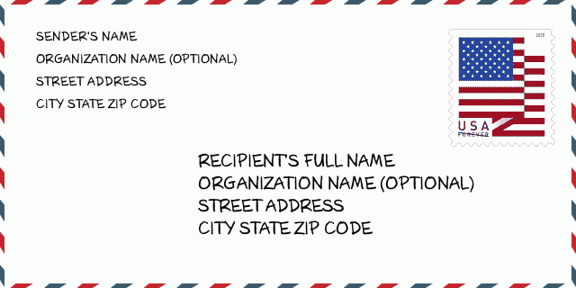
73002-2237 봉투 예제

-
이것은 미국 봉투의 예입니다. 왼쪽 상단에 보낸 사람 정보를 입력하고 오른쪽 하단에 받는 사람 정보를 입력합니다. 필요한 정보는 보낸 사람/받는 사람의 전체 이름, 주소, 도시, 주 및 우편 번호입니다. 수신자 주소 정보는 참조용으로 제공되었습니다. 일반적으로 전체 9자리 우편번호가 확실하지 않은 경우 패키지 분실을 방지하기 위해 5자리 우편번호만 입력할 수 있습니다.
73002-2237 기본 의미
-
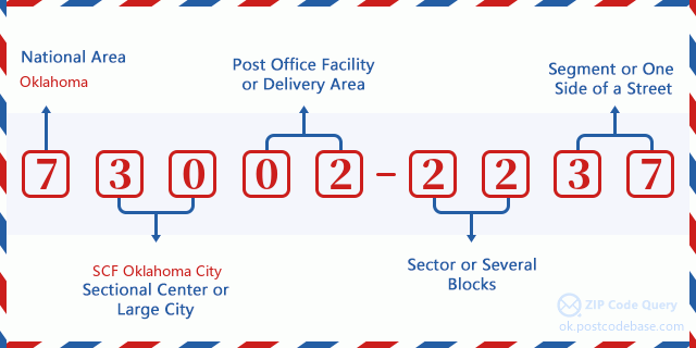
우편번호 73002-2237의 각 숫자는 무엇을 의미합니까? ZIP+4 코드는 두 부분으로 구성되며 처음 5자리는 우체국에 위치할 수 있고 마지막 4자리는 5자리 배달 지역 내 지리적 세그먼트를 식별할 수 있습니다. 6-7자리는 섹터 또는 여러 블록을 지정하고 8-9자리는 도로의 세그먼트 또는 한 면을 지정합니다.

- ·교통 노선 ID?
A 4-digit code assigned to a mail delivery or collection route within a 5-digit ZIP Code. The first character of this identification is alphabetical, and the last three are numeric: Bnnn = PO box Hnnn = Highway contract Rnnn = Rural route Cnnn = City delivery Gnnn = General delivery: H061 (고속도로 계약)
- ·우편 추가 하부?
The ZIP Add-On Low Sector and the ZIP Add-On Low Segment together form the ZIP Add-On Low Number. The ZIP Add-On Low Number is the last four positions of a ZIP+4 code; the low-end ZIP add-on in a range of codes; the add-on of the first ZIP+4 code in a consecutive series of ZIP+4 codes assigned to the delivery address. For example, most delivery addresses are assigned a single ZIP+4 code. However, large companies may be given a range of ZIP+4 codes that can be used to route mail to specific departments. A range of ZIP+4 codes can also be assigned to a corresponding range of post office boxes, and each box is mapped, one-to-one, with a ZIP+4 code in the range. A single post office box can also be assigned a range of ZIP+4 codes.: 22
- ·우편 추가 낮은 섹션?
The ZIP Add-On Low Sector and the ZIP Add-On Low Segment together form the ZIP Add-On Low Number. The ZIP Add-On Low Number is the last four positions of a ZIP+4 code; the low-end ZIP add-on in a range of codes; the add-on of the first ZIP+4 code in a consecutive series of ZIP+4 codes assigned to the delivery address. For example, most delivery addresses are assigned a single ZIP+4 code. However, large companies may be given a range of ZIP+4 codes that can be used to route mail to specific departments. A range of ZIP+4 codes can also be assigned to a corresponding range of post office boxes, and each box is mapped, one-to-one, with a ZIP+4 code in the range. A single post office box can also be assigned a range of ZIP+4 codes.: 37
- ·우편 추가 높은 섹션?
The ZIP Add-On High Sector and the ZIP Add-On High Segment together form the ZIP Add-On High Number, which is the high-end ZIP add-on in a range of codes; the add-on of the last ZIP+4 code in a consecutive series of ZIP+4 codes assigned to the delivery address. Most delivery addresses are assigned a single ZIP+4 code; however, large companies may be given a range of ZIP+4 codes that can be used to route mail to specific departments. A range of ZIP+4 codes can also be assigned to a corresponding range of post office boxes, and each box is mapped, one-to-one, with a ZIP+4 code in the range. A single post office box can also be assigned a range of ZIP+4 codes. (See also ZIP Add-On Code.): 22
- ·우편 추가 높은 세그먼트?
The ZIP Add-On High Sector and the ZIP Add-On High Segment together form the ZIP Add-On High Number, which is the high-end ZIP add-on in a range of codes; the add-on of the last ZIP+4 code in a consecutive series of ZIP+4 codes assigned to the delivery address. Most delivery addresses are assigned a single ZIP+4 code; however, large companies may be given a range of ZIP+4 codes that can be used to route mail to specific departments. A range of ZIP+4 codes can also be assigned to a corresponding range of post office boxes, and each box is mapped, one-to-one, with a ZIP+4 code in the range. A single post office box can also be assigned a range of ZIP+4 codes. (See also ZIP Add-On Code.): 37
- ·우편 번호 추가: 2237
- ·범위?
The range of +4 codes. Summing the +4 Code and the +4 Range will give you the high end of the range of +4 Codes that pertain to this ZIP Code.: 0
- ·기본 대체 코드?
Code that specifies whether a record is a base (preferred) or alternate record. Base records (represented as "B") can represent a range of addresses or an individual address, such as a firm record, while alternate records (represented as "A") are individual delivery points. Government deliveries will only be listed on alternate records with the appropriate government building indicator (federal, state, or city) set.: 기본
- ·재무 수치?
A code assigned to Postal Service facilities (primarily post offices) to collect cost and statistical data and compile revenue and expense data. The state number comprises the first two positions of the finance number.: 390176
- ·국회 지역 숫자?
A standard value identifying a geographic area within the United States served by a member of the US House of Representatives or Senate. If Army/Air Force (APO) or fleet post office (FPO), this column will be blank. If there is only one member of Congress within a state, the code will be "AL" (at large).: 04
- ·마지막 줄 도시 주 코드?
An index to the City State file that provides the preferred last-line name for this address range.: W21827
온라인 지도

주소입니다 2100 COUNTY ROAD 1420 ALEX 상응한 온라인 전자지도입니다. 이동 및 줌 버튼을 사용할 수 있습니다. 지도 정보는 참고용입니다.
주소: 2100 (From 2100 To 2199) COUNTY ROAD 1420, ALEX, OK 73002-2237, USA
댓글


댓글 달기