Adresa: 19100 (From 19100 To 19199) COUNTY ROAD 1535, ADA, OK 74820-0008, USA
Co je 74820-0008? 74820-0008 je PSČ plus 4 číslice 19100 (From 19100 To 19199) COUNTY ROAD 1535, ADA, OK, USA. Podrobnosti níže.
74820-0008 Základní informace

-
PSČ 5 Plus 4:
74820-0008 -
PSČ 5:
74820 -
Plus 4?00084-digits that are used to identify a geographic segment within the 5-digit delivery area, such as a city block or a group of apartments or an individual high-volume receiver of mail, or any other unit that could use an extra identifier to aid in efficient mail sorting and delivery. This code is the low end of the range of +4 Codes that pertain to this ZIP Code. ZIP+4 Codes associated with nondelivery areas are composed of valid ZIP sector numbers and "ND" for the ZIP segment number, for example 12345-12ND. Non-deliverable areas are areas to which the USPS does not deliver mail, such as vacant lots and land that borders railroad tracks. Mailers should not match an address identified as a nondelivery area. If you absolutely must have numeric characters in the Plus4Code column, you may treat "ND" values as "00" (zero zero).:
-
Země:
U.S. - Spojené Státy -
Země:
OK - Oklahoma -
Kraj:
CountyFIPS: 40123 - Pontotoc County -
Město:
ADA -
Ulice?COUNTY ROAD 1535The official name of a street as assigned by a local governing authority. The Street Name column contains only the street name and does not include directionals (EAST, WEST, etc.) or suffixes (ST, DR, BLVD, etc.). This element may also contain literals, such as PO BOX, GENERAL DELIVERY, USS, PSC, or UNIT. Numeric street names that have numeric components that are four characters (or less) in length at are justified such that the low-order digit of the number is positioned in the fourth position of the street name column. This shift is made so that the numeric street names appear in numeric sequence.:
-
Typ záznamu?S: UliceAn alphabetic value that identifies the type of data in the record. Record type codes include the following: G = General delivery H = Highrise F = Firm S = Street P = PO box R = Rural route/highway contract:
Adresa

- Nízké popisné číslo primární adresy?
A house, rural route, highway contract box, or post office box number; the numeric or alphanumeric component of an address preceding the street name; the low-end address in a range of addresses. Often referred to as house number.: 19100
- Vysoké popisné číslo primární adresy?
A house, rural route, contract box, or Post Office box number. The numeric or alphanumeric component of an address preceding the street name. The high-end address in a range of addresses. Often referred to as house number.: 19199
- Liché/sudé popisné číslo primární adresy?
Code that identifies the side or sides of a street for which a given address range is applicable. For street, highrise, firm and multi-carrier records, B = Both sides of a street, E = Even side of a street (even-numbered addresses in the range); O = Odd side of a street (odd-numbered addresses in the range). For general delivery, post office box, and rural route/highway contract records, this code will always be "B" (both).: Both of Odd and Even
- Hlavní Rozsah: 19100, 19101, 19102, 19103, 19104, 19105, 19106, 19107, 19108, 19109, 19110, 19111, 19112, 19113, 19114, 19115, 19116, 19117, 19118, 19119, 19120, 19121, 19122, 19123, 19124, 19125, 19126, 19127, 19128, 19129, 19130, 19131, 19132, 19133, 19134, 19135, 19136, 19137, 19138, 19139, 19140, 19141, 19142, 19143, 19144, 19145, 19146, 19147, 19148, 19149, 19150, 19151, 19152, 19153, 19154, 19155, 19156, 19157, 19158, 19159, 19160, 19161, 19162, 19163, 19164, 19165, 19166, 19167, 19168, 19169, 19170, 19171, 19172, 19173, 19174, 19175, 19176, 19177, 19178, 19179, 19180, 19181, 19182, 19183, 19184, 19185, 19186, 19187, 19188, 19189, 19190, 19191, 19192, 19193, 19194, 19195, 19196, 19197, 19198, 19199.
Kliknutím na číslo "Další příklady adres" zobrazíte celý seznam.
19100 COUNTY ROAD 1535, ADA, OK 74820-0008
19101 COUNTY ROAD 1535, ADA, OK 74820-0008
19102 COUNTY ROAD 1535, ADA, OK 74820-0008
19103 COUNTY ROAD 1535, ADA, OK 74820-0008
19104 COUNTY ROAD 1535, ADA, OK 74820-0008
19105 COUNTY ROAD 1535, ADA, OK 74820-0008
19106 COUNTY ROAD 1535, ADA, OK 74820-0008
19107 COUNTY ROAD 1535, ADA, OK 74820-0008
19108 COUNTY ROAD 1535, ADA, OK 74820-0008
19109 COUNTY ROAD 1535, ADA, OK 74820-0008
19110 COUNTY ROAD 1535, ADA, OK 74820-0008
19111 COUNTY ROAD 1535, ADA, OK 74820-0008
19112 COUNTY ROAD 1535, ADA, OK 74820-0008
19113 COUNTY ROAD 1535, ADA, OK 74820-0008
19114 COUNTY ROAD 1535, ADA, OK 74820-0008
19115 COUNTY ROAD 1535, ADA, OK 74820-0008
19116 COUNTY ROAD 1535, ADA, OK 74820-0008
19117 COUNTY ROAD 1535, ADA, OK 74820-0008
19118 COUNTY ROAD 1535, ADA, OK 74820-0008
19119 COUNTY ROAD 1535, ADA, OK 74820-0008
19120 COUNTY ROAD 1535, ADA, OK 74820-0008
19121 COUNTY ROAD 1535, ADA, OK 74820-0008
19122 COUNTY ROAD 1535, ADA, OK 74820-0008
19123 COUNTY ROAD 1535, ADA, OK 74820-0008
19124 COUNTY ROAD 1535, ADA, OK 74820-0008
19125 COUNTY ROAD 1535, ADA, OK 74820-0008
19126 COUNTY ROAD 1535, ADA, OK 74820-0008
19127 COUNTY ROAD 1535, ADA, OK 74820-0008
19128 COUNTY ROAD 1535, ADA, OK 74820-0008
19129 COUNTY ROAD 1535, ADA, OK 74820-0008
19130 COUNTY ROAD 1535, ADA, OK 74820-0008
19131 COUNTY ROAD 1535, ADA, OK 74820-0008
19132 COUNTY ROAD 1535, ADA, OK 74820-0008
19133 COUNTY ROAD 1535, ADA, OK 74820-0008
19134 COUNTY ROAD 1535, ADA, OK 74820-0008
19135 COUNTY ROAD 1535, ADA, OK 74820-0008
19136 COUNTY ROAD 1535, ADA, OK 74820-0008
19137 COUNTY ROAD 1535, ADA, OK 74820-0008
19138 COUNTY ROAD 1535, ADA, OK 74820-0008
19139 COUNTY ROAD 1535, ADA, OK 74820-0008
19140 COUNTY ROAD 1535, ADA, OK 74820-0008
19141 COUNTY ROAD 1535, ADA, OK 74820-0008
19142 COUNTY ROAD 1535, ADA, OK 74820-0008
19143 COUNTY ROAD 1535, ADA, OK 74820-0008
19144 COUNTY ROAD 1535, ADA, OK 74820-0008
19145 COUNTY ROAD 1535, ADA, OK 74820-0008
19146 COUNTY ROAD 1535, ADA, OK 74820-0008
19147 COUNTY ROAD 1535, ADA, OK 74820-0008
19148 COUNTY ROAD 1535, ADA, OK 74820-0008
19149 COUNTY ROAD 1535, ADA, OK 74820-0008
19150 COUNTY ROAD 1535, ADA, OK 74820-0008
19151 COUNTY ROAD 1535, ADA, OK 74820-0008
19152 COUNTY ROAD 1535, ADA, OK 74820-0008
19153 COUNTY ROAD 1535, ADA, OK 74820-0008
19154 COUNTY ROAD 1535, ADA, OK 74820-0008
19155 COUNTY ROAD 1535, ADA, OK 74820-0008
19156 COUNTY ROAD 1535, ADA, OK 74820-0008
19157 COUNTY ROAD 1535, ADA, OK 74820-0008
19158 COUNTY ROAD 1535, ADA, OK 74820-0008
19159 COUNTY ROAD 1535, ADA, OK 74820-0008
19160 COUNTY ROAD 1535, ADA, OK 74820-0008
19161 COUNTY ROAD 1535, ADA, OK 74820-0008
19162 COUNTY ROAD 1535, ADA, OK 74820-0008
19163 COUNTY ROAD 1535, ADA, OK 74820-0008
19164 COUNTY ROAD 1535, ADA, OK 74820-0008
19165 COUNTY ROAD 1535, ADA, OK 74820-0008
19166 COUNTY ROAD 1535, ADA, OK 74820-0008
19167 COUNTY ROAD 1535, ADA, OK 74820-0008
19168 COUNTY ROAD 1535, ADA, OK 74820-0008
19169 COUNTY ROAD 1535, ADA, OK 74820-0008
19170 COUNTY ROAD 1535, ADA, OK 74820-0008
19171 COUNTY ROAD 1535, ADA, OK 74820-0008
19172 COUNTY ROAD 1535, ADA, OK 74820-0008
19173 COUNTY ROAD 1535, ADA, OK 74820-0008
19174 COUNTY ROAD 1535, ADA, OK 74820-0008
19175 COUNTY ROAD 1535, ADA, OK 74820-0008
19176 COUNTY ROAD 1535, ADA, OK 74820-0008
19177 COUNTY ROAD 1535, ADA, OK 74820-0008
19178 COUNTY ROAD 1535, ADA, OK 74820-0008
19179 COUNTY ROAD 1535, ADA, OK 74820-0008
19180 COUNTY ROAD 1535, ADA, OK 74820-0008
19181 COUNTY ROAD 1535, ADA, OK 74820-0008
19182 COUNTY ROAD 1535, ADA, OK 74820-0008
19183 COUNTY ROAD 1535, ADA, OK 74820-0008
19184 COUNTY ROAD 1535, ADA, OK 74820-0008
19185 COUNTY ROAD 1535, ADA, OK 74820-0008
19186 COUNTY ROAD 1535, ADA, OK 74820-0008
19187 COUNTY ROAD 1535, ADA, OK 74820-0008
19188 COUNTY ROAD 1535, ADA, OK 74820-0008
19189 COUNTY ROAD 1535, ADA, OK 74820-0008
19190 COUNTY ROAD 1535, ADA, OK 74820-0008
19191 COUNTY ROAD 1535, ADA, OK 74820-0008
19192 COUNTY ROAD 1535, ADA, OK 74820-0008
19193 COUNTY ROAD 1535, ADA, OK 74820-0008
19194 COUNTY ROAD 1535, ADA, OK 74820-0008
19195 COUNTY ROAD 1535, ADA, OK 74820-0008
19196 COUNTY ROAD 1535, ADA, OK 74820-0008
19197 COUNTY ROAD 1535, ADA, OK 74820-0008
19198 COUNTY ROAD 1535, ADA, OK 74820-0008
19199 COUNTY ROAD 1535, ADA, OK 74820-0008
Adresa Příklad
ADA OK 74820-0008
UNITED STATES OF AMERICA
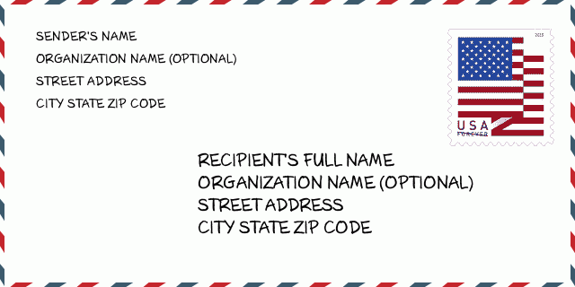
74820-0008 Příklad obálky

-
Toto je příklad americké obálky. Vyplňte informace o odesílateli vlevo nahoře a informace o příjemci vpravo dole. Potřebné informace jsou úplné jméno odesílatele/příjemce, adresa, město, stát a PSČ. Informace o adrese příjemce byly poskytnuty pro vaši informaci. Obecně platí, že pokud si nejste jisti úplným 9místným PSČ, můžete vyplnit pouze 5místné PSČ, aby nedošlo ke ztrátě balíčku.
74820-0008 Základní význam
-
Co znamená každá číslice PSČ 74820-0008? PSČ se skládá ze dvou částí, prvních pět číslic může být umístěno na poštu a poslední čtyři číslice mohou identifikovat geografický segment v rámci pětimístné oblasti doručení. 6-7 číslic označuje sektor nebo několik bloků a 8-9 číslic označuje segment nebo jednu stranu ulice.
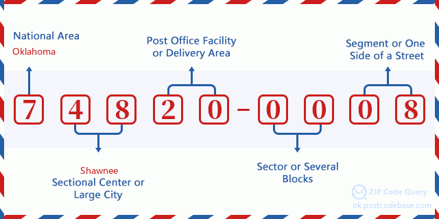

- ·Číslo trasy dopravce?
A 4-digit code assigned to a mail delivery or collection route within a 5-digit ZIP Code. The first character of this identification is alphabetical, and the last three are numeric: Bnnn = PO box Hnnn = Highway contract Rnnn = Rural route Cnnn = City delivery Gnnn = General delivery: R007 (Venkovská cesta)
- ·Doplněk PSČ nízkého sektoru?
The ZIP Add-On Low Sector and the ZIP Add-On Low Segment together form the ZIP Add-On Low Number. The ZIP Add-On Low Number is the last four positions of a ZIP+4 code; the low-end ZIP add-on in a range of codes; the add-on of the first ZIP+4 code in a consecutive series of ZIP+4 codes assigned to the delivery address. For example, most delivery addresses are assigned a single ZIP+4 code. However, large companies may be given a range of ZIP+4 codes that can be used to route mail to specific departments. A range of ZIP+4 codes can also be assigned to a corresponding range of post office boxes, and each box is mapped, one-to-one, with a ZIP+4 code in the range. A single post office box can also be assigned a range of ZIP+4 codes.: 00
- ·Doplněk PSČ nízkého segmentu?
The ZIP Add-On Low Sector and the ZIP Add-On Low Segment together form the ZIP Add-On Low Number. The ZIP Add-On Low Number is the last four positions of a ZIP+4 code; the low-end ZIP add-on in a range of codes; the add-on of the first ZIP+4 code in a consecutive series of ZIP+4 codes assigned to the delivery address. For example, most delivery addresses are assigned a single ZIP+4 code. However, large companies may be given a range of ZIP+4 codes that can be used to route mail to specific departments. A range of ZIP+4 codes can also be assigned to a corresponding range of post office boxes, and each box is mapped, one-to-one, with a ZIP+4 code in the range. A single post office box can also be assigned a range of ZIP+4 codes.: 08
- ·Doplněk PSČ vysokého sektoru?
The ZIP Add-On High Sector and the ZIP Add-On High Segment together form the ZIP Add-On High Number, which is the high-end ZIP add-on in a range of codes; the add-on of the last ZIP+4 code in a consecutive series of ZIP+4 codes assigned to the delivery address. Most delivery addresses are assigned a single ZIP+4 code; however, large companies may be given a range of ZIP+4 codes that can be used to route mail to specific departments. A range of ZIP+4 codes can also be assigned to a corresponding range of post office boxes, and each box is mapped, one-to-one, with a ZIP+4 code in the range. A single post office box can also be assigned a range of ZIP+4 codes. (See also ZIP Add-On Code.): 00
- ·Doplněk PSČ vysokého segmentu?
The ZIP Add-On High Sector and the ZIP Add-On High Segment together form the ZIP Add-On High Number, which is the high-end ZIP add-on in a range of codes; the add-on of the last ZIP+4 code in a consecutive series of ZIP+4 codes assigned to the delivery address. Most delivery addresses are assigned a single ZIP+4 code; however, large companies may be given a range of ZIP+4 codes that can be used to route mail to specific departments. A range of ZIP+4 codes can also be assigned to a corresponding range of post office boxes, and each box is mapped, one-to-one, with a ZIP+4 code in the range. A single post office box can also be assigned a range of ZIP+4 codes. (See also ZIP Add-On Code.): 08
- ·PSČ Dodatek: 0008
- ·Rozsah?
The range of +4 codes. Summing the +4 Code and the +4 Range will give you the high end of the range of +4 Codes that pertain to this ZIP Code.: 0
- ·Základní alternativní kód?
Code that specifies whether a record is a base (preferred) or alternate record. Base records (represented as "B") can represent a range of addresses or an individual address, such as a firm record, while alternate records (represented as "A") are individual delivery points. Government deliveries will only be listed on alternate records with the appropriate government building indicator (federal, state, or city) set.: Základní
- ·Finanční číslo?
A code assigned to Postal Service facilities (primarily post offices) to collect cost and statistical data and compile revenue and expense data. The state number comprises the first two positions of the finance number.: 390033
- ·Číslo kongresového okresu?
A standard value identifying a geographic area within the United States served by a member of the US House of Representatives or Senate. If Army/Air Force (APO) or fleet post office (FPO), this column will be blank. If there is only one member of Congress within a state, the code will be "AL" (at large).: 04
- ·Preferovaný městský státní klíč?
An index to the City State file that provides the preferred last-line name for this address range.: W21815
Online mapa

Toto je online mapa adresy 19100 COUNTY ROAD 1535 ADA. Pro posun a přiblížení/oddálení použijte tlačítko. Informace z mapy jsou pouze pro orientaci.
Adresa: 19100 (From 19100 To 19199) COUNTY ROAD 1535, ADA, OK 74820-0008, USA
Komentář


Přidat komentář