Адрес: 2000 (From 2000 To 2099) COUNTY ROAD 1400, BLANCHARD, OK 73010-4212, USA
Какво е 73010-4212? 73010-4212 е пощенски код 5 плюс 4 номер на 2000 (From 2000 To 2099) COUNTY ROAD 1400, BLANCHARD, OK, USA. По-долу ще откриете пълната информация.
73010-4212 Основна информация

-
Пощенска код 5 Плюс 4:
73010-4212 -
Пощенска код 5:
73010 -
Плюс 4?42124-digits that are used to identify a geographic segment within the 5-digit delivery area, such as a city block or a group of apartments or an individual high-volume receiver of mail, or any other unit that could use an extra identifier to aid in efficient mail sorting and delivery. This code is the low end of the range of +4 Codes that pertain to this ZIP Code. ZIP+4 Codes associated with nondelivery areas are composed of valid ZIP sector numbers and "ND" for the ZIP segment number, for example 12345-12ND. Non-deliverable areas are areas to which the USPS does not deliver mail, such as vacant lots and land that borders railroad tracks. Mailers should not match an address identified as a nondelivery area. If you absolutely must have numeric characters in the Plus4Code column, you may treat "ND" values as "00" (zero zero).:
-
Държава:
U.S. - Сащ -
Щат:
OK - Оклахома -
Окръг:
CountyFIPS: 40051 - Grady County -
Град:
BLANCHARD -
Улица?COUNTY ROAD 1400The official name of a street as assigned by a local governing authority. The Street Name column contains only the street name and does not include directionals (EAST, WEST, etc.) or suffixes (ST, DR, BLVD, etc.). This element may also contain literals, such as PO BOX, GENERAL DELIVERY, USS, PSC, or UNIT. Numeric street names that have numeric components that are four characters (or less) in length at are justified such that the low-order digit of the number is positioned in the fourth position of the street name column. This shift is made so that the numeric street names appear in numeric sequence.:
-
Вид запис?S: УлицаAn alphabetic value that identifies the type of data in the record. Record type codes include the following: G = General delivery H = Highrise F = Firm S = Street P = PO box R = Rural route/highway contract:
Адрес

- Основен адрес - малки номера?
A house, rural route, highway contract box, or post office box number; the numeric or alphanumeric component of an address preceding the street name; the low-end address in a range of addresses. Often referred to as house number.: 2000
- Основен адрес - големи номера?
A house, rural route, contract box, or Post Office box number. The numeric or alphanumeric component of an address preceding the street name. The high-end address in a range of addresses. Often referred to as house number.: 2099
- Основен адрес - четен/нечетен код?
Code that identifies the side or sides of a street for which a given address range is applicable. For street, highrise, firm and multi-carrier records, B = Both sides of a street, E = Even side of a street (even-numbered addresses in the range); O = Odd side of a street (odd-numbered addresses in the range). For general delivery, post office box, and rural route/highway contract records, this code will always be "B" (both).: Both of Odd and Even
- Основна обхват: 2000, 2001, 2002, 2003, 2004, 2005, 2006, 2007, 2008, 2009, 2010, 2011, 2012, 2013, 2014, 2015, 2016, 2017, 2018, 2019, 2020, 2021, 2022, 2023, 2024, 2025, 2026, 2027, 2028, 2029, 2030, 2031, 2032, 2033, 2034, 2035, 2036, 2037, 2038, 2039, 2040, 2041, 2042, 2043, 2044, 2045, 2046, 2047, 2048, 2049, 2050, 2051, 2052, 2053, 2054, 2055, 2056, 2057, 2058, 2059, 2060, 2061, 2062, 2063, 2064, 2065, 2066, 2067, 2068, 2069, 2070, 2071, 2072, 2073, 2074, 2075, 2076, 2077, 2078, 2079, 2080, 2081, 2082, 2083, 2084, 2085, 2086, 2087, 2088, 2089, 2090, 2091, 2092, 2093, 2094, 2095, 2096, 2097, 2098, 2099.
Моля, щракнете върху "Още примери за адреси", за да видите целия списък.
2000 COUNTY ROAD 1400, BLANCHARD, OK 73010-4212
2001 COUNTY ROAD 1400, BLANCHARD, OK 73010-4212
2002 COUNTY ROAD 1400, BLANCHARD, OK 73010-4212
2003 COUNTY ROAD 1400, BLANCHARD, OK 73010-4212
2004 COUNTY ROAD 1400, BLANCHARD, OK 73010-4212
2005 COUNTY ROAD 1400, BLANCHARD, OK 73010-4212
2006 COUNTY ROAD 1400, BLANCHARD, OK 73010-4212
2007 COUNTY ROAD 1400, BLANCHARD, OK 73010-4212
2008 COUNTY ROAD 1400, BLANCHARD, OK 73010-4212
2009 COUNTY ROAD 1400, BLANCHARD, OK 73010-4212
2010 COUNTY ROAD 1400, BLANCHARD, OK 73010-4212
2011 COUNTY ROAD 1400, BLANCHARD, OK 73010-4212
2012 COUNTY ROAD 1400, BLANCHARD, OK 73010-4212
2013 COUNTY ROAD 1400, BLANCHARD, OK 73010-4212
2014 COUNTY ROAD 1400, BLANCHARD, OK 73010-4212
2015 COUNTY ROAD 1400, BLANCHARD, OK 73010-4212
2016 COUNTY ROAD 1400, BLANCHARD, OK 73010-4212
2017 COUNTY ROAD 1400, BLANCHARD, OK 73010-4212
2018 COUNTY ROAD 1400, BLANCHARD, OK 73010-4212
2019 COUNTY ROAD 1400, BLANCHARD, OK 73010-4212
2020 COUNTY ROAD 1400, BLANCHARD, OK 73010-4212
2021 COUNTY ROAD 1400, BLANCHARD, OK 73010-4212
2022 COUNTY ROAD 1400, BLANCHARD, OK 73010-4212
2023 COUNTY ROAD 1400, BLANCHARD, OK 73010-4212
2024 COUNTY ROAD 1400, BLANCHARD, OK 73010-4212
2025 COUNTY ROAD 1400, BLANCHARD, OK 73010-4212
2026 COUNTY ROAD 1400, BLANCHARD, OK 73010-4212
2027 COUNTY ROAD 1400, BLANCHARD, OK 73010-4212
2028 COUNTY ROAD 1400, BLANCHARD, OK 73010-4212
2029 COUNTY ROAD 1400, BLANCHARD, OK 73010-4212
2030 COUNTY ROAD 1400, BLANCHARD, OK 73010-4212
2031 COUNTY ROAD 1400, BLANCHARD, OK 73010-4212
2032 COUNTY ROAD 1400, BLANCHARD, OK 73010-4212
2033 COUNTY ROAD 1400, BLANCHARD, OK 73010-4212
2034 COUNTY ROAD 1400, BLANCHARD, OK 73010-4212
2035 COUNTY ROAD 1400, BLANCHARD, OK 73010-4212
2036 COUNTY ROAD 1400, BLANCHARD, OK 73010-4212
2037 COUNTY ROAD 1400, BLANCHARD, OK 73010-4212
2038 COUNTY ROAD 1400, BLANCHARD, OK 73010-4212
2039 COUNTY ROAD 1400, BLANCHARD, OK 73010-4212
2040 COUNTY ROAD 1400, BLANCHARD, OK 73010-4212
2041 COUNTY ROAD 1400, BLANCHARD, OK 73010-4212
2042 COUNTY ROAD 1400, BLANCHARD, OK 73010-4212
2043 COUNTY ROAD 1400, BLANCHARD, OK 73010-4212
2044 COUNTY ROAD 1400, BLANCHARD, OK 73010-4212
2045 COUNTY ROAD 1400, BLANCHARD, OK 73010-4212
2046 COUNTY ROAD 1400, BLANCHARD, OK 73010-4212
2047 COUNTY ROAD 1400, BLANCHARD, OK 73010-4212
2048 COUNTY ROAD 1400, BLANCHARD, OK 73010-4212
2049 COUNTY ROAD 1400, BLANCHARD, OK 73010-4212
2050 COUNTY ROAD 1400, BLANCHARD, OK 73010-4212
2051 COUNTY ROAD 1400, BLANCHARD, OK 73010-4212
2052 COUNTY ROAD 1400, BLANCHARD, OK 73010-4212
2053 COUNTY ROAD 1400, BLANCHARD, OK 73010-4212
2054 COUNTY ROAD 1400, BLANCHARD, OK 73010-4212
2055 COUNTY ROAD 1400, BLANCHARD, OK 73010-4212
2056 COUNTY ROAD 1400, BLANCHARD, OK 73010-4212
2057 COUNTY ROAD 1400, BLANCHARD, OK 73010-4212
2058 COUNTY ROAD 1400, BLANCHARD, OK 73010-4212
2059 COUNTY ROAD 1400, BLANCHARD, OK 73010-4212
2060 COUNTY ROAD 1400, BLANCHARD, OK 73010-4212
2061 COUNTY ROAD 1400, BLANCHARD, OK 73010-4212
2062 COUNTY ROAD 1400, BLANCHARD, OK 73010-4212
2063 COUNTY ROAD 1400, BLANCHARD, OK 73010-4212
2064 COUNTY ROAD 1400, BLANCHARD, OK 73010-4212
2065 COUNTY ROAD 1400, BLANCHARD, OK 73010-4212
2066 COUNTY ROAD 1400, BLANCHARD, OK 73010-4212
2067 COUNTY ROAD 1400, BLANCHARD, OK 73010-4212
2068 COUNTY ROAD 1400, BLANCHARD, OK 73010-4212
2069 COUNTY ROAD 1400, BLANCHARD, OK 73010-4212
2070 COUNTY ROAD 1400, BLANCHARD, OK 73010-4212
2071 COUNTY ROAD 1400, BLANCHARD, OK 73010-4212
2072 COUNTY ROAD 1400, BLANCHARD, OK 73010-4212
2073 COUNTY ROAD 1400, BLANCHARD, OK 73010-4212
2074 COUNTY ROAD 1400, BLANCHARD, OK 73010-4212
2075 COUNTY ROAD 1400, BLANCHARD, OK 73010-4212
2076 COUNTY ROAD 1400, BLANCHARD, OK 73010-4212
2077 COUNTY ROAD 1400, BLANCHARD, OK 73010-4212
2078 COUNTY ROAD 1400, BLANCHARD, OK 73010-4212
2079 COUNTY ROAD 1400, BLANCHARD, OK 73010-4212
2080 COUNTY ROAD 1400, BLANCHARD, OK 73010-4212
2081 COUNTY ROAD 1400, BLANCHARD, OK 73010-4212
2082 COUNTY ROAD 1400, BLANCHARD, OK 73010-4212
2083 COUNTY ROAD 1400, BLANCHARD, OK 73010-4212
2084 COUNTY ROAD 1400, BLANCHARD, OK 73010-4212
2085 COUNTY ROAD 1400, BLANCHARD, OK 73010-4212
2086 COUNTY ROAD 1400, BLANCHARD, OK 73010-4212
2087 COUNTY ROAD 1400, BLANCHARD, OK 73010-4212
2088 COUNTY ROAD 1400, BLANCHARD, OK 73010-4212
2089 COUNTY ROAD 1400, BLANCHARD, OK 73010-4212
2090 COUNTY ROAD 1400, BLANCHARD, OK 73010-4212
2091 COUNTY ROAD 1400, BLANCHARD, OK 73010-4212
2092 COUNTY ROAD 1400, BLANCHARD, OK 73010-4212
2093 COUNTY ROAD 1400, BLANCHARD, OK 73010-4212
2094 COUNTY ROAD 1400, BLANCHARD, OK 73010-4212
2095 COUNTY ROAD 1400, BLANCHARD, OK 73010-4212
2096 COUNTY ROAD 1400, BLANCHARD, OK 73010-4212
2097 COUNTY ROAD 1400, BLANCHARD, OK 73010-4212
2098 COUNTY ROAD 1400, BLANCHARD, OK 73010-4212
2099 COUNTY ROAD 1400, BLANCHARD, OK 73010-4212
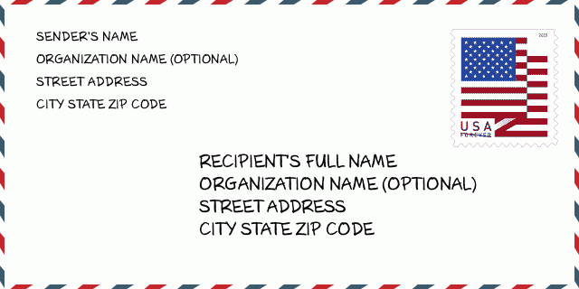
Адрес Пример
BLANCHARD OK 73010-4212
UNITED STATES OF AMERICA
73010-4212 Примерно съобщение

-
Това е пример за американски пликове. Попълнете информацията за изпращача горе вляво и информацията за получателя долу вдясно. Необходимата информация е пълното име на изпращача/получателя, адрес, град, щат и пощенски код. Информацията за адреса на получателя е дадена за ваше сведение. Като цяло, ако не сте сигурни за пълния 9-цифрен пощенски код, можете да попълните само 5-цифрения пощенски код, за да избегнете загуба на пакета.
73010-4212 Основно значение
-
Какво означава всяка цифра на пощенския код 73010-4212? ZIP+4 Code се състои от две части, като първите пет цифри могат да бъдат разположени до пощенската служба, а последните четири цифри могат да идентифицират географски сегмент в рамките на петцифрената зона за доставка. 6-7 цифри означават сектор или няколко блока, а 8-9 цифри означават сегмент или едната страна на улица.
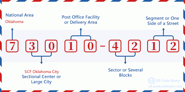

- ·Идентификационен код за маршрута на куриера?
A 4-digit code assigned to a mail delivery or collection route within a 5-digit ZIP Code. The first character of this identification is alphabetical, and the last three are numeric: Bnnn = PO box Hnnn = Highway contract Rnnn = Rural route Cnnn = City delivery Gnnn = General delivery: R003 (Междуселищна куриерска услуга)
- ·Добавка пощенски кодове - нисък сектор?
The ZIP Add-On Low Sector and the ZIP Add-On Low Segment together form the ZIP Add-On Low Number. The ZIP Add-On Low Number is the last four positions of a ZIP+4 code; the low-end ZIP add-on in a range of codes; the add-on of the first ZIP+4 code in a consecutive series of ZIP+4 codes assigned to the delivery address. For example, most delivery addresses are assigned a single ZIP+4 code. However, large companies may be given a range of ZIP+4 codes that can be used to route mail to specific departments. A range of ZIP+4 codes can also be assigned to a corresponding range of post office boxes, and each box is mapped, one-to-one, with a ZIP+4 code in the range. A single post office box can also be assigned a range of ZIP+4 codes.: 42
- ·Добавка пощенски кодове - нисък сегмент?
The ZIP Add-On Low Sector and the ZIP Add-On Low Segment together form the ZIP Add-On Low Number. The ZIP Add-On Low Number is the last four positions of a ZIP+4 code; the low-end ZIP add-on in a range of codes; the add-on of the first ZIP+4 code in a consecutive series of ZIP+4 codes assigned to the delivery address. For example, most delivery addresses are assigned a single ZIP+4 code. However, large companies may be given a range of ZIP+4 codes that can be used to route mail to specific departments. A range of ZIP+4 codes can also be assigned to a corresponding range of post office boxes, and each box is mapped, one-to-one, with a ZIP+4 code in the range. A single post office box can also be assigned a range of ZIP+4 codes.: 12
- ·Добавка пощенски кодове - висок сектор?
The ZIP Add-On High Sector and the ZIP Add-On High Segment together form the ZIP Add-On High Number, which is the high-end ZIP add-on in a range of codes; the add-on of the last ZIP+4 code in a consecutive series of ZIP+4 codes assigned to the delivery address. Most delivery addresses are assigned a single ZIP+4 code; however, large companies may be given a range of ZIP+4 codes that can be used to route mail to specific departments. A range of ZIP+4 codes can also be assigned to a corresponding range of post office boxes, and each box is mapped, one-to-one, with a ZIP+4 code in the range. A single post office box can also be assigned a range of ZIP+4 codes. (See also ZIP Add-On Code.): 42
- ·Добавка пощенски кодове - висок сегмент?
The ZIP Add-On High Sector and the ZIP Add-On High Segment together form the ZIP Add-On High Number, which is the high-end ZIP add-on in a range of codes; the add-on of the last ZIP+4 code in a consecutive series of ZIP+4 codes assigned to the delivery address. Most delivery addresses are assigned a single ZIP+4 code; however, large companies may be given a range of ZIP+4 codes that can be used to route mail to specific departments. A range of ZIP+4 codes can also be assigned to a corresponding range of post office boxes, and each box is mapped, one-to-one, with a ZIP+4 code in the range. A single post office box can also be assigned a range of ZIP+4 codes. (See also ZIP Add-On Code.): 12
- ·Пощенски Код Добавка: 4212
- ·обхват?
The range of +4 codes. Summing the +4 Code and the +4 Range will give you the high end of the range of +4 Codes that pertain to this ZIP Code.: 0
- ·Основен алтернативен код?
Code that specifies whether a record is a base (preferred) or alternate record. Base records (represented as "B") can represent a range of addresses or an individual address, such as a firm record, while alternate records (represented as "A") are individual delivery points. Government deliveries will only be listed on alternate records with the appropriate government building indicator (federal, state, or city) set.: Основен
- ·Данъчен номер?
A code assigned to Postal Service facilities (primarily post offices) to collect cost and statistical data and compile revenue and expense data. The state number comprises the first two positions of the finance number.: 390825
- ·Номер на избирателен район?
A standard value identifying a geographic area within the United States served by a member of the US House of Representatives or Senate. If Army/Air Force (APO) or fleet post office (FPO), this column will be blank. If there is only one member of Congress within a state, the code will be "AL" (at large).: 04
- ·Код на предпочитан град на последна линия?
An index to the City State file that provides the preferred last-line name for this address range.: W21875
Интерактивна карта

Това е интерактивна карта на 2000 COUNTY ROAD 1400 BLANCHARD. адресите. Можете да използвате бутона, за да местите или да приближавате/отдалечавате. Информацията на картата е само за справка.
Адрес: 2000 (From 2000 To 2099) COUNTY ROAD 1400, BLANCHARD, OK 73010-4212, USA
Коментар


Коментар