عنوان: 13600 (From 13600 To 13699) COUNTY ROAD 3590, ADA, OK 74820-0002, USA
ما هو 74820-0002؟ إنه 74820-0002هو 13600 (From 13600 To 13699) COUNTY ROAD 3590, ADA, OK, USA 5 أضاف4 الرمز البريدي. معلومات التفاصيل علي نحو التالي.
74820-0002 معلومات اساسية

-
الرمز البريدي 5 زائد 4:
74820-0002 -
الرمز البريدي 5:
74820 -
بالإضافة إلى 4?00024-digits that are used to identify a geographic segment within the 5-digit delivery area, such as a city block or a group of apartments or an individual high-volume receiver of mail, or any other unit that could use an extra identifier to aid in efficient mail sorting and delivery. This code is the low end of the range of +4 Codes that pertain to this ZIP Code. ZIP+4 Codes associated with nondelivery areas are composed of valid ZIP sector numbers and "ND" for the ZIP segment number, for example 12345-12ND. Non-deliverable areas are areas to which the USPS does not deliver mail, such as vacant lots and land that borders railroad tracks. Mailers should not match an address identified as a nondelivery area. If you absolutely must have numeric characters in the Plus4Code column, you may treat "ND" values as "00" (zero zero).:
-
بلد:
U.S. - الولايات المتحدة -
حالة:
OK - أوكلاهوما -
مقاطعة:
CountyFIPS: 40123 - Pontotoc County -
مدينة:
ADA -
شارع?COUNTY ROAD 3590The official name of a street as assigned by a local governing authority. The Street Name column contains only the street name and does not include directionals (EAST, WEST, etc.) or suffixes (ST, DR, BLVD, etc.). This element may also contain literals, such as PO BOX, GENERAL DELIVERY, USS, PSC, or UNIT. Numeric street names that have numeric components that are four characters (or less) in length at are justified such that the low-order digit of the number is positioned in the fourth position of the street name column. This shift is made so that the numeric street names appear in numeric sequence.:
-
نوع السجل?S: شارعAn alphabetic value that identifies the type of data in the record. Record type codes include the following: G = General delivery H = Highrise F = Firm S = Street P = PO box R = Rural route/highway contract:
عنوان

- الرقم المنخفض من العنوان الرئيسي ?
A house, rural route, highway contract box, or post office box number; the numeric or alphanumeric component of an address preceding the street name; the low-end address in a range of addresses. Often referred to as house number.: 13600
- الرقم العالي من العنوان الرئيسي?
A house, rural route, contract box, or Post Office box number. The numeric or alphanumeric component of an address preceding the street name. The high-end address in a range of addresses. Often referred to as house number.: 13699
- رمز فردي من العنوان الرئيسي/رمز زوجي?
Code that identifies the side or sides of a street for which a given address range is applicable. For street, highrise, firm and multi-carrier records, B = Both sides of a street, E = Even side of a street (even-numbered addresses in the range); O = Odd side of a street (odd-numbered addresses in the range). For general delivery, post office box, and rural route/highway contract records, this code will always be "B" (both).: Both of Odd and Even
- ابتدائي نطاق: 13600, 13601, 13602, 13603, 13604, 13605, 13606, 13607, 13608, 13609, 13610, 13611, 13612, 13613, 13614, 13615, 13616, 13617, 13618, 13619, 13620, 13621, 13622, 13623, 13624, 13625, 13626, 13627, 13628, 13629, 13630, 13631, 13632, 13633, 13634, 13635, 13636, 13637, 13638, 13639, 13640, 13641, 13642, 13643, 13644, 13645, 13646, 13647, 13648, 13649, 13650, 13651, 13652, 13653, 13654, 13655, 13656, 13657, 13658, 13659, 13660, 13661, 13662, 13663, 13664, 13665, 13666, 13667, 13668, 13669, 13670, 13671, 13672, 13673, 13674, 13675, 13676, 13677, 13678, 13679, 13680, 13681, 13682, 13683, 13684, 13685, 13686, 13687, 13688, 13689, 13690, 13691, 13692, 13693, 13694, 13695, 13696, 13697, 13698, 13699.
الرجاء النقر فوق "المزيد من أمثلة العنوان" لعرض القائمة بأكملها.
13600 COUNTY ROAD 3590, ADA, OK 74820-0002
13601 COUNTY ROAD 3590, ADA, OK 74820-0002
13602 COUNTY ROAD 3590, ADA, OK 74820-0002
13603 COUNTY ROAD 3590, ADA, OK 74820-0002
13604 COUNTY ROAD 3590, ADA, OK 74820-0002
13605 COUNTY ROAD 3590, ADA, OK 74820-0002
13606 COUNTY ROAD 3590, ADA, OK 74820-0002
13607 COUNTY ROAD 3590, ADA, OK 74820-0002
13608 COUNTY ROAD 3590, ADA, OK 74820-0002
13609 COUNTY ROAD 3590, ADA, OK 74820-0002
13610 COUNTY ROAD 3590, ADA, OK 74820-0002
13611 COUNTY ROAD 3590, ADA, OK 74820-0002
13612 COUNTY ROAD 3590, ADA, OK 74820-0002
13613 COUNTY ROAD 3590, ADA, OK 74820-0002
13614 COUNTY ROAD 3590, ADA, OK 74820-0002
13615 COUNTY ROAD 3590, ADA, OK 74820-0002
13616 COUNTY ROAD 3590, ADA, OK 74820-0002
13617 COUNTY ROAD 3590, ADA, OK 74820-0002
13618 COUNTY ROAD 3590, ADA, OK 74820-0002
13619 COUNTY ROAD 3590, ADA, OK 74820-0002
13620 COUNTY ROAD 3590, ADA, OK 74820-0002
13621 COUNTY ROAD 3590, ADA, OK 74820-0002
13622 COUNTY ROAD 3590, ADA, OK 74820-0002
13623 COUNTY ROAD 3590, ADA, OK 74820-0002
13624 COUNTY ROAD 3590, ADA, OK 74820-0002
13625 COUNTY ROAD 3590, ADA, OK 74820-0002
13626 COUNTY ROAD 3590, ADA, OK 74820-0002
13627 COUNTY ROAD 3590, ADA, OK 74820-0002
13628 COUNTY ROAD 3590, ADA, OK 74820-0002
13629 COUNTY ROAD 3590, ADA, OK 74820-0002
13630 COUNTY ROAD 3590, ADA, OK 74820-0002
13631 COUNTY ROAD 3590, ADA, OK 74820-0002
13632 COUNTY ROAD 3590, ADA, OK 74820-0002
13633 COUNTY ROAD 3590, ADA, OK 74820-0002
13634 COUNTY ROAD 3590, ADA, OK 74820-0002
13635 COUNTY ROAD 3590, ADA, OK 74820-0002
13636 COUNTY ROAD 3590, ADA, OK 74820-0002
13637 COUNTY ROAD 3590, ADA, OK 74820-0002
13638 COUNTY ROAD 3590, ADA, OK 74820-0002
13639 COUNTY ROAD 3590, ADA, OK 74820-0002
13640 COUNTY ROAD 3590, ADA, OK 74820-0002
13641 COUNTY ROAD 3590, ADA, OK 74820-0002
13642 COUNTY ROAD 3590, ADA, OK 74820-0002
13643 COUNTY ROAD 3590, ADA, OK 74820-0002
13644 COUNTY ROAD 3590, ADA, OK 74820-0002
13645 COUNTY ROAD 3590, ADA, OK 74820-0002
13646 COUNTY ROAD 3590, ADA, OK 74820-0002
13647 COUNTY ROAD 3590, ADA, OK 74820-0002
13648 COUNTY ROAD 3590, ADA, OK 74820-0002
13649 COUNTY ROAD 3590, ADA, OK 74820-0002
13650 COUNTY ROAD 3590, ADA, OK 74820-0002
13651 COUNTY ROAD 3590, ADA, OK 74820-0002
13652 COUNTY ROAD 3590, ADA, OK 74820-0002
13653 COUNTY ROAD 3590, ADA, OK 74820-0002
13654 COUNTY ROAD 3590, ADA, OK 74820-0002
13655 COUNTY ROAD 3590, ADA, OK 74820-0002
13656 COUNTY ROAD 3590, ADA, OK 74820-0002
13657 COUNTY ROAD 3590, ADA, OK 74820-0002
13658 COUNTY ROAD 3590, ADA, OK 74820-0002
13659 COUNTY ROAD 3590, ADA, OK 74820-0002
13660 COUNTY ROAD 3590, ADA, OK 74820-0002
13661 COUNTY ROAD 3590, ADA, OK 74820-0002
13662 COUNTY ROAD 3590, ADA, OK 74820-0002
13663 COUNTY ROAD 3590, ADA, OK 74820-0002
13664 COUNTY ROAD 3590, ADA, OK 74820-0002
13665 COUNTY ROAD 3590, ADA, OK 74820-0002
13666 COUNTY ROAD 3590, ADA, OK 74820-0002
13667 COUNTY ROAD 3590, ADA, OK 74820-0002
13668 COUNTY ROAD 3590, ADA, OK 74820-0002
13669 COUNTY ROAD 3590, ADA, OK 74820-0002
13670 COUNTY ROAD 3590, ADA, OK 74820-0002
13671 COUNTY ROAD 3590, ADA, OK 74820-0002
13672 COUNTY ROAD 3590, ADA, OK 74820-0002
13673 COUNTY ROAD 3590, ADA, OK 74820-0002
13674 COUNTY ROAD 3590, ADA, OK 74820-0002
13675 COUNTY ROAD 3590, ADA, OK 74820-0002
13676 COUNTY ROAD 3590, ADA, OK 74820-0002
13677 COUNTY ROAD 3590, ADA, OK 74820-0002
13678 COUNTY ROAD 3590, ADA, OK 74820-0002
13679 COUNTY ROAD 3590, ADA, OK 74820-0002
13680 COUNTY ROAD 3590, ADA, OK 74820-0002
13681 COUNTY ROAD 3590, ADA, OK 74820-0002
13682 COUNTY ROAD 3590, ADA, OK 74820-0002
13683 COUNTY ROAD 3590, ADA, OK 74820-0002
13684 COUNTY ROAD 3590, ADA, OK 74820-0002
13685 COUNTY ROAD 3590, ADA, OK 74820-0002
13686 COUNTY ROAD 3590, ADA, OK 74820-0002
13687 COUNTY ROAD 3590, ADA, OK 74820-0002
13688 COUNTY ROAD 3590, ADA, OK 74820-0002
13689 COUNTY ROAD 3590, ADA, OK 74820-0002
13690 COUNTY ROAD 3590, ADA, OK 74820-0002
13691 COUNTY ROAD 3590, ADA, OK 74820-0002
13692 COUNTY ROAD 3590, ADA, OK 74820-0002
13693 COUNTY ROAD 3590, ADA, OK 74820-0002
13694 COUNTY ROAD 3590, ADA, OK 74820-0002
13695 COUNTY ROAD 3590, ADA, OK 74820-0002
13696 COUNTY ROAD 3590, ADA, OK 74820-0002
13697 COUNTY ROAD 3590, ADA, OK 74820-0002
13698 COUNTY ROAD 3590, ADA, OK 74820-0002
13699 COUNTY ROAD 3590, ADA, OK 74820-0002
عنوان مثال
ADA OK 74820-0002
UNITED STATES OF AMERICA
74820-0002 مثال المغلف

-
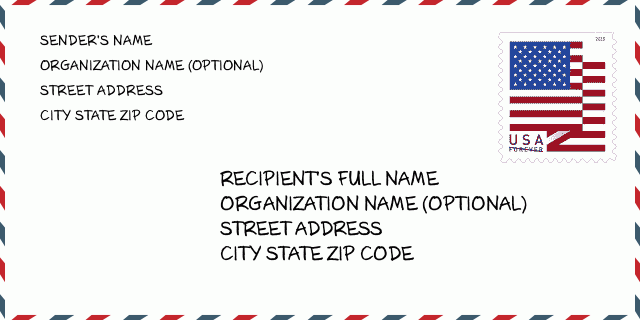
هذا مثال على مغلف الولايات المتحدة. املأ معلومات المرسل في أعلى اليسار ومعلومات المستلم في أسفل اليمين. المعلومات الضرورية هي الاسم الكامل للمرسل / المستلم وعنوان الشارع والمدينة والولاية والرمز البريدي. تم تقديم معلومات عنوان المستلم كمرجع لك. بشكل عام ، إذا لم تكن متأكدًا من الرمز البريدي الكامل المكون من 9 أرقام ، فيمكنك فقط ملء الرمز البريدي المكون من 5 أرقام لتجنب فقد الحزمة.
74820-0002 المعنى الأساسي
-
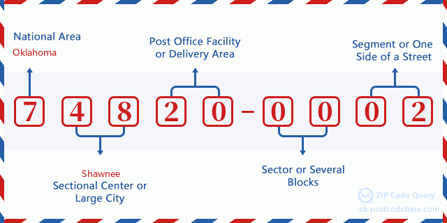
ما الذي يرمز إليه كل رقم في الرمز البريدي 74820-0002؟ يتكون الرمز البريدي + 4 من جزأين ، يمكن تحديد موقع أول خمسة أرقام في مكتب البريد ، ويمكن للأرقام الأربعة الأخيرة تحديد مقطع جغرافي داخل منطقة التسليم المكونة من خمسة أرقام. تحدد الأرقام المكونة من 6 إلى 7 أرقام قطاعًا أو عدة كتل ، بينما تحدد الأرقام المكونة من 8 إلى 9 أرقام مقطعًا أو جانبًا واحدًا من الشارع.

- ·طرق النقل ID?
A 4-digit code assigned to a mail delivery or collection route within a 5-digit ZIP Code. The first character of this identification is alphabetical, and the last three are numeric: Bnnn = PO box Hnnn = Highway contract Rnnn = Rural route Cnnn = City delivery Gnnn = General delivery: R007 (المسار الريفية)
- ·أضاف البريد علي قطاع منخفضة?
The ZIP Add-On Low Sector and the ZIP Add-On Low Segment together form the ZIP Add-On Low Number. The ZIP Add-On Low Number is the last four positions of a ZIP+4 code; the low-end ZIP add-on in a range of codes; the add-on of the first ZIP+4 code in a consecutive series of ZIP+4 codes assigned to the delivery address. For example, most delivery addresses are assigned a single ZIP+4 code. However, large companies may be given a range of ZIP+4 codes that can be used to route mail to specific departments. A range of ZIP+4 codes can also be assigned to a corresponding range of post office boxes, and each box is mapped, one-to-one, with a ZIP+4 code in the range. A single post office box can also be assigned a range of ZIP+4 codes.: 00
- ·أضاف البريد علي جزء منخفضة?
The ZIP Add-On Low Sector and the ZIP Add-On Low Segment together form the ZIP Add-On Low Number. The ZIP Add-On Low Number is the last four positions of a ZIP+4 code; the low-end ZIP add-on in a range of codes; the add-on of the first ZIP+4 code in a consecutive series of ZIP+4 codes assigned to the delivery address. For example, most delivery addresses are assigned a single ZIP+4 code. However, large companies may be given a range of ZIP+4 codes that can be used to route mail to specific departments. A range of ZIP+4 codes can also be assigned to a corresponding range of post office boxes, and each box is mapped, one-to-one, with a ZIP+4 code in the range. A single post office box can also be assigned a range of ZIP+4 codes.: 02
- ·أضاف البريد علي قطاع عالية?
The ZIP Add-On High Sector and the ZIP Add-On High Segment together form the ZIP Add-On High Number, which is the high-end ZIP add-on in a range of codes; the add-on of the last ZIP+4 code in a consecutive series of ZIP+4 codes assigned to the delivery address. Most delivery addresses are assigned a single ZIP+4 code; however, large companies may be given a range of ZIP+4 codes that can be used to route mail to specific departments. A range of ZIP+4 codes can also be assigned to a corresponding range of post office boxes, and each box is mapped, one-to-one, with a ZIP+4 code in the range. A single post office box can also be assigned a range of ZIP+4 codes. (See also ZIP Add-On Code.): 00
- ·أضاف البريد علي جزء عالية?
The ZIP Add-On High Sector and the ZIP Add-On High Segment together form the ZIP Add-On High Number, which is the high-end ZIP add-on in a range of codes; the add-on of the last ZIP+4 code in a consecutive series of ZIP+4 codes assigned to the delivery address. Most delivery addresses are assigned a single ZIP+4 code; however, large companies may be given a range of ZIP+4 codes that can be used to route mail to specific departments. A range of ZIP+4 codes can also be assigned to a corresponding range of post office boxes, and each box is mapped, one-to-one, with a ZIP+4 code in the range. A single post office box can also be assigned a range of ZIP+4 codes. (See also ZIP Add-On Code.): 02
- ·الرمز البريدي ملحق: 0002
- ·نطاق?
The range of +4 codes. Summing the +4 Code and the +4 Range will give you the high end of the range of +4 Codes that pertain to this ZIP Code.: 0
- ·رمز البديل الأساسي?
Code that specifies whether a record is a base (preferred) or alternate record. Base records (represented as "B") can represent a range of addresses or an individual address, such as a firm record, while alternate records (represented as "A") are individual delivery points. Government deliveries will only be listed on alternate records with the appropriate government building indicator (federal, state, or city) set.: قاعدة
- ·الأرقام المالية?
A code assigned to Postal Service facilities (primarily post offices) to collect cost and statistical data and compile revenue and expense data. The state number comprises the first two positions of the finance number.: 390033
- ·رقم منطقة الكونغرس?
A standard value identifying a geographic area within the United States served by a member of the US House of Representatives or Senate. If Army/Air Force (APO) or fleet post office (FPO), this column will be blank. If there is only one member of Congress within a state, the code will be "AL" (at large).: 04
- ·رمز المدينة المفضلة الأخير?
An index to the City State file that provides the preferred last-line name for this address range.: W21815
خريطة الانترنت

هذا هو عنوان 13600 COUNTY ROAD 3590 ADA مطابقة الخريطة الإلكترونية عبر الإنترنت يمكنك استخدام زر في الخريطة للتحرك وتكبير. معلومات الخريطة هي للإشارة فقط.
عنوان: 13600 (From 13600 To 13699) COUNTY ROAD 3590, ADA, OK 74820-0002, USA
التعليق


إضافة تعليق جديد