Indirizzo: 9118 S (South) WESTERN AVE STE A (From A To F), OKLAHOMA CITY, OK 73139-2728, USA
Che cos'è 73139-2728? 73139-2728 è un codice di 5 Plus 4 numero di avviamento postale del 9118 S (South) WESTERN AVE STE A (From A To F), OKLAHOMA CITY, OK, USA. Di seguito è riportato informazioni dettagliate.
73139-2728 Informazioni di base

Via Predirezionale?
A geographic direction that precedes the street name.
| Strada?
The official name of a street as assigned by a local governing authority. The Street Name column contains only the street name and does not include directionals (EAST, WEST, etc.) or suffixes (ST, DR, BLVD, etc.). This element may also contain literals, such as PO BOX, GENERAL DELIVERY, USS, PSC, or UNIT. Numeric street names that have numeric components that are four characters (or less) in length at are justified such that the low-order digit of the number is positioned in the fourth position of the street name column. This shift is made so that the numeric street names appear in numeric sequence.
| Via Suffisso?
The street suffix:
For Example:
ST = Street
RD = Road
DR = Drive
LN = Lane
| Città | Tipo di Record?
An alphabetic value that identifies the type of data in the record. Record type codes include the following:
G = General delivery
H = Highrise
F = Firm
S = Street
P = PO box
R = Rural route/highway contract
| Stato |
|---|---|---|---|---|---|
| S (South) | WESTERN | AVE | OKLAHOMA CITY | H | valido |
| S (South) | WESTERN | AVE | OKLAHOMA CITY | F | non valido |
Indirizzo

73139-2728 corrisponde ai seguenti indirizzi.
| Elenco indirizzi | Stato |
|---|---|
| 9118 S (South) WESTERN AVE, OKLAHOMA CITY, OK 73139-2728, USA | valido |
| 9301 S (South) WESTERN AVE, OKLAHOMA CITY, OK 73139-2728, USA | non valido |
| 9118 S (South) WESTERN AVE STE A (From A To F), OKLAHOMA CITY, OK 73139-2728, USA | valido |
L'indirizzo corrispondente al CAP+4 73139-2728 è cambiato. Conserviamo le informazioni vecchie e nuove del codice postale 73139-2728, controlla lo stato. Se il tuo indirizzo è contrassegnato come non valido in questa pagina, non sarai in grado di utilizzare 73139-2728 come codice postale postale.
Indirizzo Esempio
OKLAHOMA CITY OK 73139-2728
UNITED STATES OF AMERICA
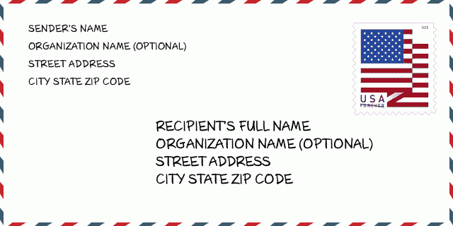
73139-2728 Esempio di busta

-
Questo è un esempio di busta statunitense. Inserisci le informazioni del mittente in alto a sinistra e le informazioni del destinatario in basso a destra. Le informazioni necessarie sono il nome completo del mittente/destinatario, l'indirizzo, la città, lo stato e il codice postale. Le informazioni sull'indirizzo del destinatario sono state fornite come riferimento. In generale, se non sei sicuro del codice postale completo di 9 cifre, puoi inserire solo il codice postale di 5 cifre per evitare la perdita del pacco.
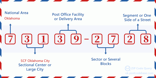
73139-2728 Significato di base
-
Cosa significa ogni cifra del CAP 73139-2728? Il CAP+4 è composto da due parti, le prime cinque cifre possono essere localizzate all'ufficio postale e le ultime quattro cifre possono identificare un segmento geografico all'interno dell'area di consegna a cinque cifre. Le 6-7 cifre indicano un settore o più blocchi e le 8-9 cifre indicano un segmento o un lato di una strada.

Online Mappa

Questa è la online mappa dell'indirizzo 9118 S (South) WESTERN AVE, OKLAHOMA CITY. Possibile usare bottone a muovere e sfrecciare in/fuori. Le informazioni di mappa è solo per riferimento.
Indirizzo: 9118 S (South) WESTERN AVE STE A (From A To F), OKLAHOMA CITY, OK 73139-2728, USA
Commento


Aggiungi un commento